Home > Arts > Artists > W > Edward Adrian Wilson
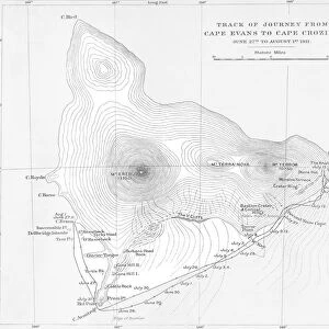
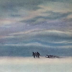
Section of Map from Ross Island to South Pole used on Antarctica Expedition, 1910-12

![]()
Wall Art and Photo Gifts from Fine Art Finder
Section of Map from Ross Island to South Pole used on Antarctica Expedition, 1910-12
BAL4387 Section of Map from Ross Island to South Pole used on Antarctica Expedition, 1910-12 by Wilson, Edward Adrian (1872-1912); Scott Polar Research Institute, University of Cambridge, UK; (add.info.: Robert Falcon Scott (1868-1912); reached South Pole January 1912; Scott and his men died on return journey; ); English, out of copyright
Media ID 18249345
© Scott Polar Research Institute, University of Cambridge, UK / Bridgeman Images
Antarctic Captain Chart Terra Nova
FEATURES IN THESE COLLECTIONS
> Arts
> Artists
> S
> Robert Falcon Scott
> Arts
> Artists
> W
> Edward Adrian Wilson
> Arts
> Artists
> W
> Wilson Wilson
> Europe
> United Kingdom
> Maps
> Fine Art Finder
> Artists
> Edward Adrian Wilson
> Fine Art Finder
> Maps (celestial & Terrestrial)
> Maps and Charts
> Related Images
> Popular Themes
> Antarctic Expedition
EDITORS COMMENTS
This print showcases a section of the map that was used during the historic Antarctica Expedition of 1910-12. The map, meticulously crafted by Edward Adrian Wilson, provides an invaluable glimpse into the route taken from Ross Island to the South Pole. The expedition, led by renowned explorer Robert Falcon Scott, aimed to be the first to reach the elusive South Pole. In January 1912, Scott and his team achieved their goal but tragically lost their lives on their arduous return journey. The image captures not only a piece of history but also highlights the immense bravery and determination exhibited by these early Antarctic explorers. It serves as a testament to their unwavering spirit in pushing boundaries and venturing into uncharted territories. Displayed at the Scott Polar Research Institute at the University of Cambridge in the UK, this photograph print allows us to reflect upon both triumphs and sacrifices made in pursuit of scientific discovery and human achievement. As we gaze upon this remarkable chart filled with exploration routes and annotations, we are reminded of those who dared to challenge nature's harshest conditions for knowledge and adventure. This visual representation invites us to appreciate our planet's vastness while honoring those who paved the way for future generations of explorers.
MADE IN THE USA
Safe Shipping with 30 Day Money Back Guarantee
FREE PERSONALISATION*
We are proud to offer a range of customisation features including Personalised Captions, Color Filters and Picture Zoom Tools
SECURE PAYMENTS
We happily accept a wide range of payment options so you can pay for the things you need in the way that is most convenient for you
* Options may vary by product and licensing agreement. Zoomed Pictures can be adjusted in the Cart.