Home > Aerial Photography > Related Images
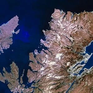
Firth of Forth, UK, satellite image

![]()
Wall Art and Photo Gifts from Science Photo Library
Firth of Forth, UK, satellite image
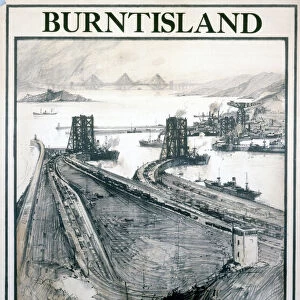
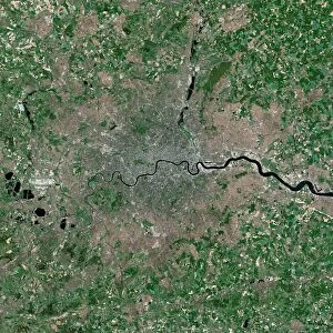
Firth of Forth, UK, satellite image. The Firth of Forth is the major estuary of the River Forth in Scotland. The grey area at centre is the city of Edinburgh, The area is of major industrial and economic importance and includes the petrochemical sites of Grangemouth and Burntisland as well as several major ports and docks which have access to the North Sea (top right corner). Several major bridges cross the Firth including the Forth Road Bridge
Science Photo Library features Science and Medical images including photos and illustrations
Media ID 6375343
© PLANETOBSERVER/SCIENCE PHOTO LIBRARY
Aerial Photography British Isles City Earth Observation Earth Science Edinburgh Estuary From Space Great North Sea Satellite Satellite Image Sciences Scot Land Firth Firth Of Forth River Forth
FEATURES IN THESE COLLECTIONS
> Aerial Photography
> Related Images
> Aerial Photography
> Scotland
> Architecture
> Bridges
> Forth Bridge
> Arts
> Landscape paintings
> Waterfall and river artworks
> River artworks
> Europe
> France
> Canton
> Landes
> Europe
> Related Images
> Europe
> United Kingdom
> Heritage Sites
> The Forth Bridge
> Europe
> United Kingdom
> Related Images
> Europe
> United Kingdom
> Scotland
> Edinburgh
EDITORS COMMENTS
This satellite image showcases the stunning Firth of Forth in the United Kingdom. The focal point of this print is the vibrant city of Edinburgh, depicted as a grey area at the center. As Scotland's major estuary, the Firth of Forth holds immense industrial and economic significance. It encompasses various petrochemical sites like Grangemouth and Burntisland, along with bustling ports and docks that provide access to the North Sea. The photograph also highlights several remarkable bridges that span across the Firth, including the iconic Forth Road Bridge. This breathtaking aerial view offers a glimpse into both natural beauty and human ingenuity. With its rich history and diverse industries, this region plays a crucial role in shaping Britain's economy. The image captures not only an exquisite landscape but also represents progress and development in 21st-century Europe. Science Photo Library presents this extraordinary satellite image from space, showcasing Earth's intricate geography through advanced earth observation techniques. From afar, one can appreciate how nature intertwines with industry in this dynamic part of Great Britain.
MADE IN THE USA
Safe Shipping with 30 Day Money Back Guarantee
FREE PERSONALISATION*
We are proud to offer a range of customisation features including Personalised Captions, Color Filters and Picture Zoom Tools
SECURE PAYMENTS
We happily accept a wide range of payment options so you can pay for the things you need in the way that is most convenient for you
* Options may vary by product and licensing agreement. Zoomed Pictures can be adjusted in the Cart.