Home > Arts > Artists > B > Emanuel Bowen
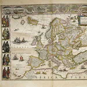
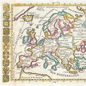
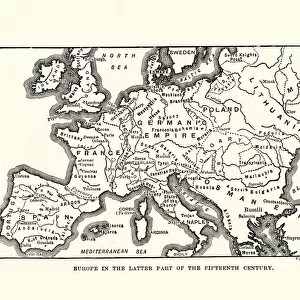
Antique Map of Europe 1744

![]()
Wall Art and Photo Gifts from Fine Art Storehouse
Antique Map of Europe 1744
An engraved map of Europe with ornamental cartouche and relief shown pictorially by Emanuel Bowen 1744, London, Geographer to His Majesty, being all new-drawn and engraved according to the latest discoveries and surveys of the period
Unleash your creativity and transform your space into a visual masterpiece!
BernardAllum
Media ID 13597641
© BernardAllum
Atlantic Ocean Cartouche Coat Of Arms Denmark Dirty Document Geographical Border Greece Grunge Grunge Image Technique Mediterranean Sea Nation National National Border Norway Paper Past Picture Frame Poland Retro Revival Russia Sweden Travel Backgrounds Travel Locations Turkey Turkey Middle East World Map Retro Styled
FEATURES IN THESE COLLECTIONS
> Arts
> Artists
> B
> Emanuel Bowen
> Arts
> Artists
> O
> Oceanic Oceanic
> Asia
> Turkey
> Related Images
> Europe
> Denmark
> Related Images
> Fine Art Storehouse
> Map
> Denmark Maps
> Fine Art Storehouse
> Map
> Historical Maps
> Fine Art Storehouse
> Map
> Italian Maps
EDITORS COMMENTS
This print takes us on a journey through time, immersing us in the rich history of Europe. An exquisite Antique Map of Europe from 1744, meticulously engraved by Emanuel Bowen, transports us to an era when cartography was both an art form and a scientific endeavor. The map itself is a true masterpiece, adorned with an ornamental cartouche and relief that depict the continent's diverse landscapes pictorially. Created in London under the title "Geographer to His Majesty" this map represents the latest discoveries and surveys of its time. As we gaze upon this vintage treasure, we are reminded of the intricate national borders that have shaped European nations for centuries. From Turkey to Russia, Poland to Spain, Italy to Greece – each country is distinctly outlined within its historical context. The faded paper and grungy appearance lend authenticity to this antique gem. Its worn edges tell tales of countless hands flipping through its pages over generations. The coat of arms scattered across Europe symbolizes pride and identity for each nation it represents. Transported back in time by this retro-styled image technique, we can almost hear whispers from the past as we explore these travel locations etched onto the map's surface. The Mediterranean Sea connects with the vast Atlantic Ocean – reminding us how geography has shaped trade routes and cultural exchanges throughout history. Bernard Allum's skillful photography captures not only a document but also nostalgia itself. This print invites us into a world where exploration was at its peak and maps
MADE IN THE USA
Safe Shipping with 30 Day Money Back Guarantee
FREE PERSONALISATION*
We are proud to offer a range of customisation features including Personalised Captions, Color Filters and Picture Zoom Tools
SECURE PAYMENTS
We happily accept a wide range of payment options so you can pay for the things you need in the way that is most convenient for you
* Options may vary by product and licensing agreement. Zoomed Pictures can be adjusted in the Cart.