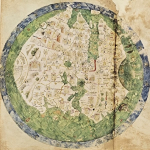
Andrea Biancos Atlas, 1436. Page 10. Map of the

![]()
Wall Art and Photo Gifts from Mary Evans Picture Library
Andrea Biancos Atlas, 1436. Page 10. Map of the
Andrea Biancos Atlas, 1436. Page 10.Map of the Ptolemaic World from a conic view. Miniature Painting. ITALY. Venice. Biblioteca nazionale marciana (St. Marks Library)
Mary Evans Picture Library makes available wonderful images created for people to enjoy over the centuries
Media ID 8261031
© Mary Evans Picture Library 2015 - https://copyrighthub.org/s0/hub1/creation/maryevans/MaryEvansPictureID/10681644
Andrea Atlas Biblioteca Conic Illuminated Manuscript Manuscripts Marciana Miniatures Nazionale Ptolemaic Venice Bianco
EDITORS COMMENTS
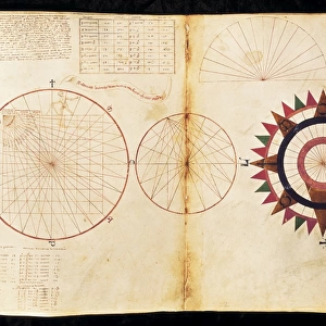
Andrea Bianco's Atlas, created in 1436, is a rare and exquisite example of an illuminated manuscript map from the Renaissance period. This particular image is from Page 10 of the atlas, which showcases a Ptolemaic world map viewed from a conic perspective. The map is a miniature painting, measuring only a few centimeters in size, yet it is rich in detail and vibrant color. The map was produced in Venice, Italy, during a time when cartography was undergoing a significant transformation. Andrea Bianco's atlas represents one of the earliest known examples of a printed world map, and it was produced using a technique known as woodcut engraving. This method allowed for the mass production of maps, making them more accessible to a wider audience. The map on Page 10 of Andrea Bianco's Atlas is based on the geographical knowledge of the ancient Greek scholar Ptolemy, who lived around AD 150. However, Bianco made some modifications to Ptolemy's original work, incorporating new information from contemporary explorers and cartographers. The map is housed in the Biblioteca Nazionale Marciana, or St. Mark's Library, in Venice. This historic library is one of the oldest public libraries in Europe and is renowned for its extensive collection of rare and valuable manuscripts and miniatures. The library's holdings include over one million printed books, as well as thousands of manuscripts and ancient documents. Andrea Bianco's Atlas is a testament to the rich cultural heritage of Venice during the Renaissance period. Its intricate details and vibrant colors continue to captivate scholars and enthusiasts of cartography and history alike. This image provides a glimpse into the past, offering a window into the world as it was understood during the 15th century.
MADE IN THE USA
Safe Shipping with 30 Day Money Back Guarantee
FREE PERSONALISATION*
We are proud to offer a range of customisation features including Personalised Captions, Color Filters and Picture Zoom Tools
SECURE PAYMENTS
We happily accept a wide range of payment options so you can pay for the things you need in the way that is most convenient for you
* Options may vary by product and licensing agreement. Zoomed Pictures can be adjusted in the Cart.