Home > Europe > Italy > Veneto > Venice
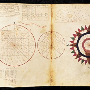
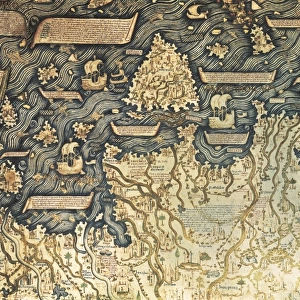
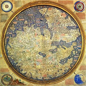
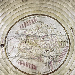
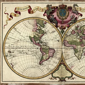
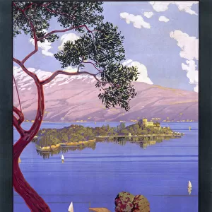
Andrea Biancos Atlas, 1436. Page 10, World Map

![]()
Wall Art and Photo Gifts from Mary Evans Picture Library
Andrea Biancos Atlas, 1436. Page 10, World Map
" Andrea Biancos Atlas, 1436. Page 10, World Map, the East is on the upper side. First time Florida coast is depicted as a big peninsula linked to an island called Antillia (legendary island) or " ilha das Sete Cidades" in Portuguese. Miniature Painting. ITALY. Venice. Biblioteca nazionale marciana (St. Marks Library)."
Mary Evans Picture Library makes available wonderful images created for people to enjoy over the centuries
Media ID 8280433
© Mary Evans Picture Library 2015 - https://copyrighthub.org/s0/hub1/creation/maryevans/MaryEvansPictureID/10684458
Andrea Atlas Called Depicted Florida Legendary Linked Peninsula Ilha Upper
FEATURES IN THESE COLLECTIONS
> Asia
> East Timor
> Maps
> Asia
> East Timor
> Related Images
> Europe
> Italy
> Related Images
> Europe
> Italy
> Veneto
> Venice
> Europe
> Portugal
> Paintings
EDITORS COMMENTS
Andrea Bianco's Atlas, 1436: A Glimpse into the Uncharted Waters of the Early Modern World (Page 10) Andrea Bianco's Atlas, created in 1436, is a rare and intriguing testament to the exploratory spirit of the early modern world. This magnificent map, housed in the Biblioteca Nazionale Marciana in Venice, Italy, offers a fascinating glimpse into the geographical knowledge and myths of the time. On this particular page (10), the East is depicted on the upper side, with the Atlantic Ocean to the west and the Indian Ocean to the east. The coast of Florida is shown for the first time as a large peninsula, extending from the southern tip of what is now the United States, and linked to an island called Antillia or 'ilha das Sete Cidades' in Portuguese. Antillia, a legendary island, has been a subject of much debate among historians and cartographers. Some believe it to be the island of Bimini, while others argue it may be the Bahamas or even Cuba. The name 'ilha das Sete Cidades' translates to 'island of the seven cities,' suggesting a place of great significance and prosperity. The miniature painting, a masterpiece of Renaissance cartography, is a captivating reminder of the mysteries and discoveries that awaited explorers in the uncharted waters of the 15th century. With the East on the upper side, the map invites us to look beyond the known world and imagine the possibilities that lay beyond the horizon.
MADE IN THE USA
Safe Shipping with 30 Day Money Back Guarantee
FREE PERSONALISATION*
We are proud to offer a range of customisation features including Personalised Captions, Color Filters and Picture Zoom Tools
SECURE PAYMENTS
We happily accept a wide range of payment options so you can pay for the things you need in the way that is most convenient for you
* Options may vary by product and licensing agreement. Zoomed Pictures can be adjusted in the Cart.