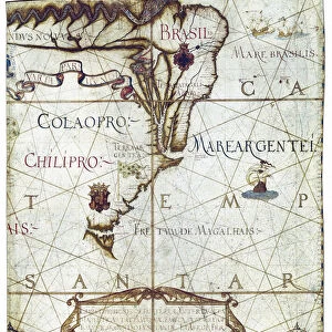
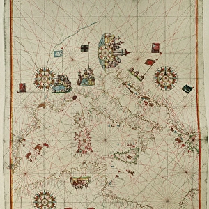
Universa ac Navigabilis Totius Terrarum Orbis

![]()
Wall Art and Photo Gifts from Mary Evans Picture Library
Universa ac Navigabilis Totius Terrarum Orbis
Mary Evans Picture Library makes available wonderful images created for people to enjoy over the centuries
Media ID 8271299
© Mary Evans Picture Library 2015 - https://copyrighthub.org/s0/hub1/creation/maryevans/MaryEvansPictureID/10686816
Andr Atlas Cartographer Cartographic Cartographies Cartography Descriptio Illuminated Manuscript Manuscripts Maps Miniatures Orbis Portuguese Terrarum Totius Homem Up Right
EDITORS COMMENTS
This stunning illuminated map, titled "Universa ac Navigabilis Totius Terrarum Orbis" or "The Whole and Navigable World," is a rare and captivating example of early modern cartography. Created in the late 16th century, possibly by a Portuguese cartographer, this intricately detailed manuscript map is a testament to the exploratory spirit of the age. The map is depicted in a vertical format, with the southern hemisphere at the top and the northern hemisphere at the bottom. The vibrant colors and meticulous miniature illustrations bring the known world to life, with each continent and body of water meticulously rendered. The map's title and cartouche are adorned with intricate gold and silver illumination, adding to its grandeur and sophistication. The map's significance lies not only in its visual beauty but also in its historical importance. At the time of its creation, Europeans were actively exploring and mapping new territories, particularly in the Americas. This map reflects the latest knowledge of the world at the time, with new discoveries and explorations beginning to reshape the understanding of the globe. The map's title, "Universa ac Navigabilis Totius Terrarum Orbis," reflects the belief that the entire world was now navigable, a notion that was only recently becoming a reality. The map's influence can be seen in later cartographic works, making it an essential piece of the history of cartography and exploration. This map is a remarkable example of the art and science of cartography during the Renaissance period. Its intricate details, vibrant colors, and historical significance make it a valuable and captivating addition to any collection of maps or manuscripts.
MADE IN THE USA
Safe Shipping with 30 Day Money Back Guarantee
FREE PERSONALISATION*
We are proud to offer a range of customisation features including Personalised Captions, Color Filters and Picture Zoom Tools
SECURE PAYMENTS
We happily accept a wide range of payment options so you can pay for the things you need in the way that is most convenient for you
* Options may vary by product and licensing agreement. Zoomed Pictures can be adjusted in the Cart.