Home > Europe > France > Paris > Maps
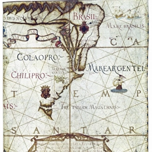
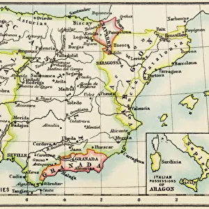
Map of South America, in Universa ac Navigabilis Totius Terrarum Orbis Descriptio 1559 (colour manuscript)
")
![]()
Wall Art and Photo Gifts from Fine Art Finder
Map of South America, in Universa ac Navigabilis Totius Terrarum Orbis Descriptio 1559 (colour manuscript)
AIS5334419 Map of South America, in Universa ac Navigabilis Totius Terrarum Orbis Descriptio 1559 (colour manuscript) by Homem, Andre (16th century); Bibliotheque Nationale, Paris, France; (add.info.: Map of South America. Colour manuscript, 1559, in Universa ac Navigabilis Totius Terrarum Orbis Descriptio, by Andre Homem (16th century, Portuguese cartographer).
Illuminated manuscript on parchment, 10 pages, 60 x 75 cm
Bibliotheque nationale de France, departement des Cartes et Plans, CPL GE CC-2719 (RES)); © Iberfoto; Portuguese, out of copyright
Media ID 25196824
© Iberfoto / Bridgeman Images
Atlas Book Of Maps Brazil Brasilian Brazil Brazilian City Map City Plan General Map Illuminated Ms Latinamerica Portugal Portugal Portuguese Portugese Portuguese Portugueses Southamerica Street Plan America Continent Americhe Geographical Map Latine America
FEATURES IN THESE COLLECTIONS
> Animals
> Mammals
> Muridae
> Western Mouse
> Arts
> Portraits
> Pop art gallery
> Street art portraits
> Europe
> France
> Paris
> Maps
> Europe
> France
> Paris
> Related Images
> Europe
> Portugal
> Related Images
> Fine Art Finder
> Artists
> (c.1440-1502) Dionisius the Wise
> Maps and Charts
> Early Maps
EDITORS COMMENTS
This vibrant and detailed map of South America, created in 1559 by Portuguese cartographer Andre Homem, offers a fascinating glimpse into the geographical knowledge of the time. The manuscript, illuminated on parchment and consisting of 10 pages measuring 60 x 75 cm, is currently housed in the Bibliotheque Nationale in Paris. Homem's map provides a comprehensive depiction of the continent, showcasing its diverse landscapes and highlighting major cities and regions. As one explores this ancient cartographic masterpiece, it becomes evident that Homem possessed an impressive understanding of South America's geography. The intricate details captured within this colorful manuscript offer valuable insights into how Europeans perceived the New World during the 16th century. It serves as a testament to both Homem's skill as a cartographer and his dedication to accurately representing these distant lands. From Brazil to North America, this map encompasses not only South American territories but also parts of what is now known as the United States. Its significance lies not only in its historical value but also in its ability to transport viewers back in time to an era when exploration was at its peak. As we examine this remarkable piece of artistry from centuries past, we are reminded of how far our understanding has come since then while appreciating the beauty and intricacy that went into creating such an invaluable artifact.
MADE IN THE USA
Safe Shipping with 30 Day Money Back Guarantee
FREE PERSONALISATION*
We are proud to offer a range of customisation features including Personalised Captions, Color Filters and Picture Zoom Tools
SECURE PAYMENTS
We happily accept a wide range of payment options so you can pay for the things you need in the way that is most convenient for you
* Options may vary by product and licensing agreement. Zoomed Pictures can be adjusted in the Cart.