Home > North America > United States of America > New York > New York > Maps
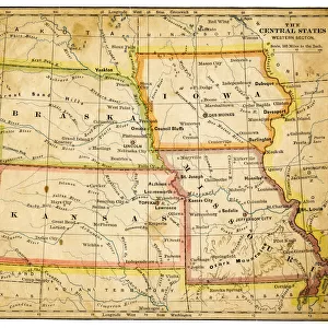
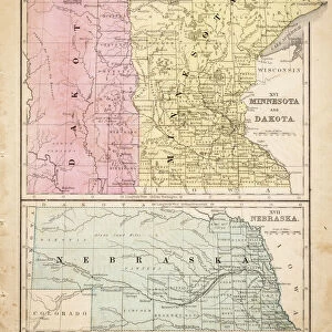
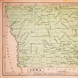
Map of central states USA 1895

![]()
Wall Art and Photo Gifts from Fine Art Storehouse
Map of central states USA 1895
The Rand-McNally Grammar School Geography 1895 - Chicago & New York
Unleash your creativity and transform your space into a visual masterpiece!
THEPALMER
Media ID 14824617
© This content is subject to copyright
Iowa Kansas Minnesota Missouri Nebraska North Dakota South Dakota
FEATURES IN THESE COLLECTIONS
> Fine Art Storehouse
> Map
> Historical Maps
> Fine Art Storehouse
> Map
> USA Maps
> Maps and Charts
> Related Images
> North America
> United States of America
> Iowa
> Related Images
> North America
> United States of America
> Kansas
> Related Images
> North America
> United States of America
> Maps
> North America
> United States of America
> Minnesota
> Related Images
> North America
> United States of America
> Missouri
> Related Images
> North America
> United States of America
> Nebraska
> Related Images
> North America
> United States of America
> New York
> New York
> Maps
> North America
> United States of America
> New York
> Related Images
> North America
> United States of America
> North Dakota
> Related Images
EDITORS COMMENTS
In this print titled "Map of central states USA 1895" we are transported back in time to a bygone era. The image showcases an exquisite piece of historical cartography, taken from "The Rand-McNally Grammar School Geography 1895" publication, which was published in both Chicago and New York. This particular map focuses on the central states of the United States, including North Dakota, South Dakota, Iowa, Kansas, Minnesota, Missouri, and Nebraska. As we gaze upon this meticulously detailed artwork created by THEPALMER for Fine Art Storehouse, we cannot help but marvel at the craftsmanship that went into its creation. Every contour and boundary is intricately drawn with precision and accuracy. It serves as a reminder of a time when maps were not just tools for navigation but also works of art. The vintage aesthetic adds an extra layer of charm to this already enchanting composition. The faded colors evoke nostalgia while simultaneously highlighting the rich history contained within these borders. Whether you have personal ties to these central states or simply appreciate the beauty found in antique maps like this one, it is impossible not to be captivated by its allure. "The Map of Central States USA 1895" offers us a glimpse into America's past—a snapshot frozen in time—allowing us to reflect on how much has changed since then while appreciating the enduring legacy left behind by those who came before us.
MADE IN THE USA
Safe Shipping with 30 Day Money Back Guarantee
FREE PERSONALISATION*
We are proud to offer a range of customisation features including Personalised Captions, Color Filters and Picture Zoom Tools
SECURE PAYMENTS
We happily accept a wide range of payment options so you can pay for the things you need in the way that is most convenient for you
* Options may vary by product and licensing agreement. Zoomed Pictures can be adjusted in the Cart.