Home > Asia > Georgia > Maps
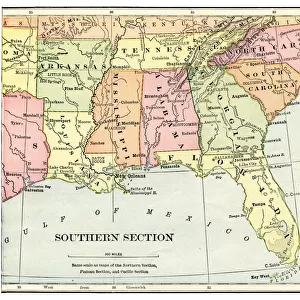
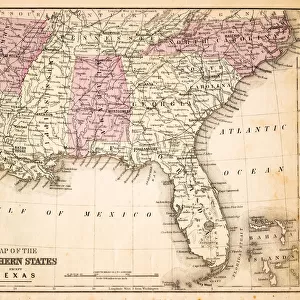
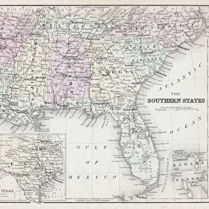
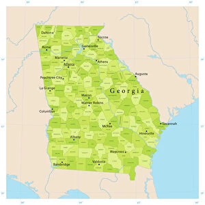
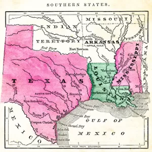
Map of USA Southern states 1869

![]()
Wall Art and Photo Gifts from Fine Art Storehouse
Map of USA Southern states 1869
Cornells Grammars-School Geography - S.S. Cornell - New York D. Appleton and Company 1869
Unleash your creativity and transform your space into a visual masterpiece!
THEPALMER
Media ID 13669021
© Roberto A Sanchez
Alabama Atlantic Ocean Backgrounds Bay Of Water Caribbean Sea Dirty East Florida Us State Florida Usa Georgia Us State Gulf Coast States Kentucky Mexico North Carolina North Carolina Us State Paper Patina Scale Sepia Toned South South Carolina Southern Usa Stained Tennessee Textured Effect Virginia Virginia Us State Obsolete Retro Styled
FEATURES IN THESE COLLECTIONS
> Fine Art Storehouse
> The Magical World of Illustration
> Palmer Illustrated Collection
> Fine Art Storehouse
> Map
> Historical Maps
> Fine Art Storehouse
> Map
> USA Maps
> USA Southern States Historical Maps
> Fine Art Storehouse
> Map
> USA Maps
> Maps and Charts
> Early Maps
> Maps and Charts
> World
> North America
> Mexico
> Related Images
> North America
> United States of America
> Alabama
> Related Images
> North America
> United States of America
> Florida
> Related Images
> North America
> United States of America
> Georgia
> Related Images
> North America
> United States of America
> Kentucky
> Related Images
> North America
> United States of America
> Maps
EDITORS COMMENTS
This print takes us back in time to the year 1869, showcasing a beautifully engraved image of the Map of USA Southern states. With its retro-styled appearance and textured effect, this piece exudes a sense of nostalgia and charm. The map itself is filled with intricate details, displaying the southern region of the United States during that era. The stained and dirty paper adds an authentic touch to this vintage artwork, emphasizing its age and historical significance. From east to south, we can trace our eyes across the horizontal layout, exploring states such as Florida, Virginia, South Carolina, North Carolina, Tennessee, Kentucky, Georgia Alabama - all part of the vibrant tapestry that makes up the southern USA. As we delve deeper into this engraving's patina-toned hues and sepia tones reminiscent of old photographs from yesteryears; we notice additional geographical features like Mexico bordering these southern states along with stunning bodies of water including bays and coastlines along both Atlantic Ocean and Caribbean Sea. This illustration serves as a reminder of how maps were once meticulously crafted by hand before modern technology took over. It invites us to appreciate not only its artistic value but also offers a glimpse into America's past. A true collector's item for history enthusiasts or anyone seeking to add a touch of vintage allure to their space.
MADE IN THE USA
Safe Shipping with 30 Day Money Back Guarantee
FREE PERSONALISATION*
We are proud to offer a range of customisation features including Personalised Captions, Color Filters and Picture Zoom Tools
SECURE PAYMENTS
We happily accept a wide range of payment options so you can pay for the things you need in the way that is most convenient for you
* Options may vary by product and licensing agreement. Zoomed Pictures can be adjusted in the Cart.