Home > North America > United States of America > New York > New York > Maps
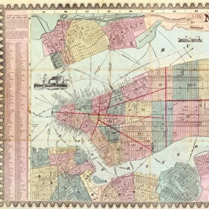
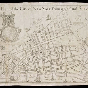
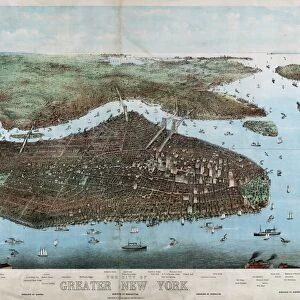
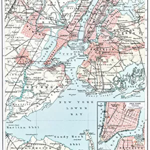
Bridgmans new map of the City of New York divided in boroughs with its environs

![]()
Wall Art and Photo Gifts from Fine Art Finder
Bridgmans new map of the City of New York divided in boroughs with its environs
1079246 Bridgmans new map of the City of New York divided in boroughs with its environs, 1898 (black and colour ink on paper, backed with cloth) by American School, (19th century); 80x69 cm cm; Collection of the New-York Historical Society, USA; (add.info.: Bridgmans new map of the City of New York divided in boroughs with its environs, 1898
Bridgman, E.C.); eNew York Historical Society; American, out of copyright
Media ID 22212092
© New York Historical Society / Bridgeman Images
Borough Boroughs Bronx Brooklyn New Jersey Queens Staten Island States Surveys
FEATURES IN THESE COLLECTIONS
> Fine Art Finder
> Artists
> American School
> Maps and Charts
> Early Maps
> Maps and Charts
> Related Images
> North America
> United States of America
> Maps
> North America
> United States of America
> New Jersey
> Jersey City
> North America
> United States of America
> New Jersey
> Related Images
> North America
> United States of America
> New York
> New York
> Bronx
> Related Images
> North America
> United States of America
> New York
> New York
> Brooklyn
> Related Images
> North America
> United States of America
> New York
> New York
> Maps
> North America
> United States of America
> New York
> New York
> Queens
> Related Images
EDITORS COMMENTS
This print showcases Bridgman's new map of the City of New York, created in 1898. The map is divided into boroughs with its environs, providing a detailed and comprehensive view of the city during that time period. Measuring 80x69 cm, this black and color ink on paper piece is backed with cloth for added durability. The Collection of the New-York Historical Society proudly houses this remarkable artwork by an anonymous American School artist from the 19th century. It offers a fascinating glimpse into the history and development of one of America's most iconic cities. The map encompasses not only Manhattan but also highlights other boroughs such as Queens, Staten Island, Bronx, and Brooklyn. Additionally, it includes neighboring areas like New Jersey to provide a broader understanding of the region's geography. With its intricate details and precise surveying techniques, this map serves as both a historical artifact and an invaluable resource for researchers studying urban planning or tracing their family roots within these neighborhoods. Displayed against a neutral background, this print captures every minute detail while preserving its vintage charm. Whether you are an art enthusiast or simply intrigued by New York City's rich history, this image will undoubtedly transport you back in time to experience the grandeur and complexity of early 20th-century America.
MADE IN THE USA
Safe Shipping with 30 Day Money Back Guarantee
FREE PERSONALISATION*
We are proud to offer a range of customisation features including Personalised Captions, Color Filters and Picture Zoom Tools
SECURE PAYMENTS
We happily accept a wide range of payment options so you can pay for the things you need in the way that is most convenient for you
* Options may vary by product and licensing agreement. Zoomed Pictures can be adjusted in the Cart.