Home > Maps and Charts > Americas
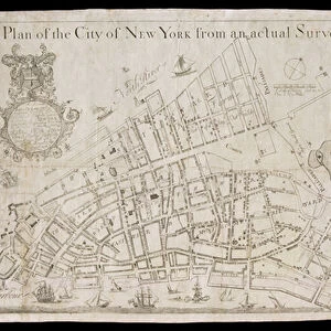
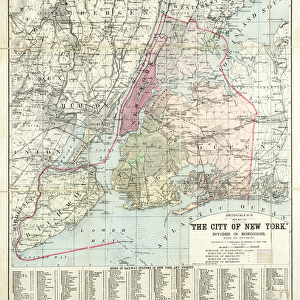
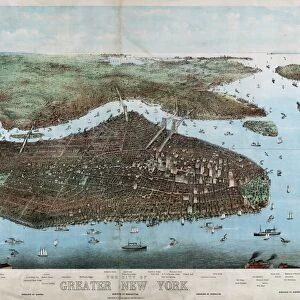
New York City Map, 1857, 1857 (black ink on paper, colour wash)
")
![]()
Wall Art and Photo Gifts from Fine Art Finder
New York City Map, 1857, 1857 (black ink on paper, colour wash)
1079240 New York City Map, 1857, 1857 (black ink on paper, colour wash) by American School, (19th century); 38x66, on sheet 43x74 cm; Collection of the New-York Historical Society, USA; (add.info.: Covers Manhattan below 132nd Street, Brooklyn north of Union Street and west of Fifth or Union Avenues, and part of western Queens, all in New York (N.Y.); also covers Jersey City and Hoboken in New Jersey
Humphrey Phelps); eNew York Historical Society; American, out of copyright
Media ID 23537792
© New York Historical Society / Bridgeman Images
Brooklyn Central Park Manhattan Survey Surveys
FEATURES IN THESE COLLECTIONS
> Fine Art Finder
> Artists
> American School
> Maps and Charts
> Early Maps
> Maps and Charts
> Related Images
> North America
> United States of America
> Maps
> North America
> United States of America
> New Jersey
> Jersey City
> North America
> United States of America
> New Jersey
> Related Images
> North America
> United States of America
> New York
> New York
> Brooklyn
> Related Images
> North America
> United States of America
> New York
> New York
> Manhattan
> Central Park
> North America
> United States of America
> New York
> New York
> Manhattan
> Related Images
> North America
> United States of America
> New York
> New York
> Maps
EDITORS COMMENTS
This black ink and color wash print showcases the detailed map of New York City in 1857. Created by the American School in the 19th century, this historical piece measures 38x66 cm on a sheet of 43x74 cm. It is now part of the esteemed collection at the New-York Historical Society in the USA. The map encompasses Manhattan below 132nd Street, Brooklyn north of Union Street and west of Fifth or Union Avenues, as well as parts of western Queens. Additionally, it includes Jersey City and Hoboken in New Jersey. This comprehensive representation offers a glimpse into how these areas were structured during that era. Notable features depicted on this map include Central Park, which stands out with its green expanse amidst the urban landscape. The intricate street surveys provide insight into how city planning was carried out back then. As we explore this artwork further, we are transported to a time when America was still developing as a nation. The United States' growth can be traced through this visual documentation of one of its most iconic cities. Bridgeman Images has beautifully preserved this historic print from Fine Art Finder for us to appreciate today. Let us immerse ourselves in its rich details and marvel at how much has changed since those early days while appreciating our shared history.
MADE IN THE USA
Safe Shipping with 30 Day Money Back Guarantee
FREE PERSONALISATION*
We are proud to offer a range of customisation features including Personalised Captions, Color Filters and Picture Zoom Tools
SECURE PAYMENTS
We happily accept a wide range of payment options so you can pay for the things you need in the way that is most convenient for you
* Options may vary by product and licensing agreement. Zoomed Pictures can be adjusted in the Cart.