Home > Arts > Artists > O > Abraham Ortelius
ORTELIUS, Abraham (1527-1598). Theatrum Orbis Terrarum
. Theatrum Orbis Terrarum")
![]()
Wall Art and Photo Gifts from Mary Evans Picture Library
ORTELIUS, Abraham (1527-1598). Theatrum Orbis Terrarum
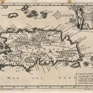
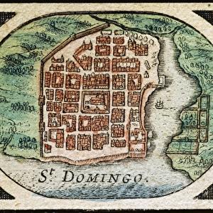
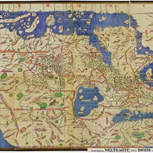
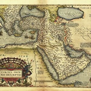
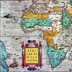
ORTELIUS, Abraham (1527-1598). Theatrum Orbis Terrarum. 1570. It is considered to be the first modern atlas. Map of the Caribbean Sea with the islands of Cuba, Cayman Islands, Hispaniola (Dominican Republic and Haiti), Puerto Rico and Jamaica. ca. 1588. Etching. SPAIN. MADRID (AUTONOMOUS COMMUNITY). Madrid. Americas Museum
Mary Evans Picture Library makes available wonderful images created for people to enjoy over the centuries
Media ID 14182362
© Iberfoto/Mary Evans
1527 1570 1588 1598 Abraham Atlas Autonomous Caribbean Cayman Community Considered Cuba Cuban Cubans Dominican Engravings Espa X6fb21 Espanola Etching Etchings Geographic Geographical Geography Haiti Haitian Hispaniola Indies Jamaica Orbis Ortelius Ponce Puerto Rico Terrarum Theatrum Caribbeans
FEATURES IN THESE COLLECTIONS
> Arts
> Artists
> O
> Abraham Ortelius
> Europe
> Spain
> Related Images
> Maps and Charts
> Abraham Ortelius
> Maps and Charts
> Related Images
> Maps and Charts
> Spain
> North America
> Cuba
> Maps
EDITORS COMMENTS
This print is a testament to the groundbreaking work of Flemish cartographer Abraham Ortelius (1527-1598), considered the father of modern cartography. The image showcases a section from his seminal work, "Theatrum Orbis Terrarum," published in 1570, which is widely regarded as the world's first modern atlas. This particular map focuses on the Caribbean Sea, highlighting several major islands, including Cuba, the Cayman Islands, Hispaniola (home to the Dominican Republic and Haiti), Puerto Rico, and Jamaica. The map, created around 1588, is an intricately detailed etching that showcases the geographical knowledge of the time. The Spanish influence is evident in the naming conventions, with the island of La Española, for instance, named after the Spanish explorer, Juan Ponce de León. The map's historical significance is further underscored by its current location at the Americas Museum in Madrid, Spain, an autonomous community. This enchanting piece of cartographic history offers a fascinating glimpse into the geographical understanding of the Caribbean region during the late 16th century.
MADE IN THE USA
Safe Shipping with 30 Day Money Back Guarantee
FREE PERSONALISATION*
We are proud to offer a range of customisation features including Personalised Captions, Color Filters and Picture Zoom Tools
SECURE PAYMENTS
We happily accept a wide range of payment options so you can pay for the things you need in the way that is most convenient for you
* Options may vary by product and licensing agreement. Zoomed Pictures can be adjusted in the Cart.