Home > Europe > United Kingdom > England > Berkshire > Chieveley
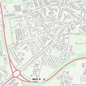
West Berkshire RG18 9 Map

![]()
Wall Art and Photo Gifts from Map Marketing
West Berkshire RG18 9 Map
Postcode Sector Map of West Berkshire RG18 9
Media ID 19980534
Ash Terrace Blake Road Chapel Lane Charlotte Close Crabtree Close Crabtree Lane Doctors Lane Drove Lane Fishers Lane Harewood Drive Hermitage Road Holly Lane Kiln Close Kiln Drive Long Lane Manor Lane Marsh Lane Newbury Road Oaklands Old Street Orchard Close Pinewood Crescent Plantation Close Pond Lane Ridgeway Close Sandy Close Sandy Lane Spring Lane Station Road Stoney Lane The Ridge The Rise Thompson Close Vicarage Lane Walters Close West Berkshire White Close Woodlands Close Woodside Woodside Drive Hermitage Oare
FEATURES IN THESE COLLECTIONS
> Europe
> United Kingdom
> England
> Berkshire
> Chieveley
> Europe
> United Kingdom
> England
> Berkshire
> Cold Ash
> Europe
> United Kingdom
> England
> Berkshire
> Hungerford
> Europe
> United Kingdom
> England
> Berkshire
> Newbury
> Europe
> United Kingdom
> England
> Berkshire
> Related Images
> Europe
> United Kingdom
> England
> Berkshire
> The Ridges
> Europe
> United Kingdom
> England
> Berkshire
> The Rise
> Europe
> United Kingdom
> England
> Berkshire
> Woodside
> Map Marketing
> Postcode Sector Maps
> RG - Reading
> Maps and Charts
> Related Images
MADE IN THE USA
Safe Shipping with 30 Day Money Back Guarantee
FREE PERSONALISATION*
We are proud to offer a range of customisation features including Personalised Captions, Color Filters and Picture Zoom Tools
SECURE PAYMENTS
We happily accept a wide range of payment options so you can pay for the things you need in the way that is most convenient for you
* Options may vary by product and licensing agreement. Zoomed Pictures can be adjusted in the Cart.