Home > Europe > United Kingdom > England > London > Boroughs > Camden
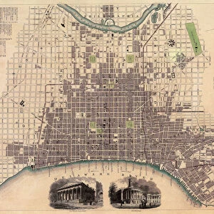
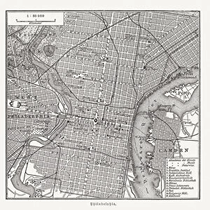
Philadelphia City Map

![]()
Wall Art and Photo Gifts from Map Marketing
Philadelphia City Map
A street level map of central Philadelphia based on USGS topo map data. Covers from Feltonville in the north to the Navy Yard in the south and from Camden in the east to Wynnefield in the west
Media ID 19949369
© Map Marketing Ltd, Map Data courtesy of USGS
Street Map Pennsylvania Philadelphia
FEATURES IN THESE COLLECTIONS
> Europe
> United Kingdom
> England
> London
> Boroughs
> Camden
> Maps and Charts
> Related Images
> North America
> United States of America
> Pennsylvania
> Philadelphia
> Services
> Royal Navy
MADE IN THE USA
Safe Shipping with 30 Day Money Back Guarantee
FREE PERSONALISATION*
We are proud to offer a range of customisation features including Personalised Captions, Color Filters and Picture Zoom Tools
SECURE PAYMENTS
We happily accept a wide range of payment options so you can pay for the things you need in the way that is most convenient for you
* Options may vary by product and licensing agreement. Zoomed Pictures can be adjusted in the Cart.