Home > Animals > Mammals > Muridae > House Mouse
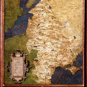
General Map of Vilnius Province: Showing Postal and Major Roads, Stations and the... 1820. Creators: Vasilii Petrovich Piadyshev, Iwanoff

![]()
Wall Art and Photo Gifts from Heritage Images
General Map of Vilnius Province: Showing Postal and Major Roads, Stations and the... 1820. Creators: Vasilii Petrovich Piadyshev, Iwanoff
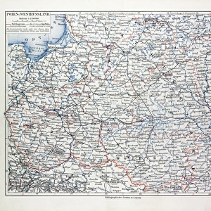
General Map of Vilnius Province: Showing Postal and Major Roads, Stations and the Distance in Versts between Them, 1820. This 1820 map of Vilnius Provinceis from a larger work, Geograficheskii atlas Rossiiskoi imperii, tsarstva Pol'skogo i velikogo kniazhestva Finliandskogo(Geographical atlas of the Russian Empire, the Kingdom of Poland, and the Grand Duchy of Finland), containing 60 maps of the Russian Empire. Compiled and engraved by Colonel V.P. Piadyshev, it reflects the detailed mapping carried out by Russian military cartographers in the first quarter of the 19th century. The map shows population centers (six gradations by size), postal stations, roads (four types), state, provincial and district borders, taverns, and customs outposts. Distances are shown in versts, a Russian measure, now no longer used, equal to 1.07 kilometers.Legends and place-names are in Russian and Polish. The territory depicted on the map corresponds to parts of present-day Lithuania and Belarus
Heritage Images features heritage image collections
Media ID 35128077
© Heritage Art/Heritage Images
1820s Belarus Border Cartographer Cartographic Cartography Communication Customs House Cyrillic Iwanoff Legend Map Making Mapmaker Mapmaking Military Topographical Depot Piadyshev Vasilii Petrovich Poland Polish Postal Station Public House Roads Russian Empire Russian Federation Tavern Thoroughfare Vasilii Petrovich Piadyshev Vp Piadyshev Meeting Of Frontiers Postal Service
FEATURES IN THESE COLLECTIONS
> Animals
> Mammals
> Muridae
> House Mouse
> Arts
> Photorealistic artworks
> Detailed art pieces
> Masterful detailing in art
> Europe
> Belarus
> Related Images
> Europe
> Finland
> Related Images
> Europe
> Lithuania
> Posters
> Europe
> Lithuania
> Related Images
EDITORS COMMENTS
This historic map print, titled "General Map of Vilnius Province: Showing Postal and Major Roads, Stations and the Distance in Versts between Them," dates back to 1820. It is an extract from the larger work, "Geograficheskii atlas Rossiiskoi imperii, tsarstva Pol'skogo i velikogo kniazhestva Finliandskogo" (Geographical atlas of the Russian Empire, the Kingdom of Poland, and the Grand Duchy of Finland), which consisted of 60 maps of the Russian Empire. The map was compiled and engraved by Colonel Vasilii Petrovich Piadyshev and Iwanoff. The map displays an intricate and detailed representation of Vilnius Province, which covered parts of present-day Lithuania and Belarus. The map's meticulousness is a testament to the extensive mapping efforts carried out by Russian military cartographers during the first quarter of the 19th century. The map includes various features such as population centers (indicated by six gradations based on size), postal stations, roads (classified into four types), state, provincial, and district borders, taverns, and customs outposts. Distances are measured in versts, a Russian unit of measurement now obsolete, equivalent to approximately 1.07 kilometers. Legends and place-names on the map are presented in both Russian and Polish, reflecting the multicultural makeup of the region during that time. The map's meticulous detail and historical significance make it an essential resource for researchers, historians, and anyone interested in the history of Eastern Europe during the Russian Empire era.
MADE IN THE USA
Safe Shipping with 30 Day Money Back Guarantee
FREE PERSONALISATION*
We are proud to offer a range of customisation features including Personalised Captions, Color Filters and Picture Zoom Tools
SECURE PAYMENTS
We happily accept a wide range of payment options so you can pay for the things you need in the way that is most convenient for you
* Options may vary by product and licensing agreement. Zoomed Pictures can be adjusted in the Cart.