Home > Maps and Charts > Early Maps
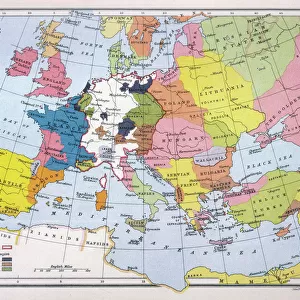
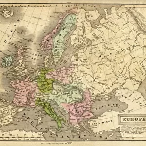
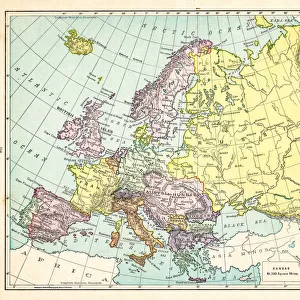
Map / Europe C1130

![]()
Wall Art and Photo Gifts from Mary Evans Picture Library
Map / Europe C1130
Map of Europe in the 12th century Date: circa 1130
Mary Evans Picture Library makes available wonderful images created for people to enjoy over the centuries
Media ID 14291495
© Mary Evans Picture Library
FEATURES IN THESE COLLECTIONS
> Europe
> Related Images
> Maps and Charts
> Early Maps
> Maps and Charts
> Related Images
EDITORS COMMENTS
This map print, titled Map of Europe in the 12th Century, C1130, offers a fascinating glimpse into the historical geography of Europe during a pivotal period in its development. Dated circa 1130, this map is an essential addition to any collection focusing on European history or cartography. The map, which originated from the 12th century, is a testament to the advancements in cartography during this era. Despite its age, the intricacy and detail of the map are remarkable, revealing the extent of European knowledge at the time. The map includes various geographical features, such as major rivers, mountains, and cities, providing valuable insights into the political and cultural landscape of Europe during the Middle Ages. One of the most striking aspects of this map is its representation of Europe's northernmost reaches, which were still largely unexplored during this time. The map shows a vast expanse of water, believed to be the North Sea, extending far beyond the known territories. This underscores the sense of adventure and exploration that characterized the European world during the Middle Ages. The map also highlights the political divisions of Europe during the 12th century, with various kingdoms, duchies, and principalities depicted in intricate detail. The map's accuracy may not be consistent with modern standards, but its historical significance cannot be overstated. It serves as a reminder of the rich and complex history of Europe and the remarkable progress that was made in cartography during the Middle Ages. In conclusion, this Map of Europe in the 12th Century, C1130, is a must-have for anyone interested in European history, cartography, or the Middle Ages. Its intricate detail, historical significance, and captivating design make it a truly unique and valuable addition to any collection.
MADE IN THE USA
Safe Shipping with 30 Day Money Back Guarantee
FREE PERSONALISATION*
We are proud to offer a range of customisation features including Personalised Captions, Color Filters and Picture Zoom Tools
SECURE PAYMENTS
We happily accept a wide range of payment options so you can pay for the things you need in the way that is most convenient for you
* Options may vary by product and licensing agreement. Zoomed Pictures can be adjusted in the Cart.