Home > Europe > United Kingdom > England > Cheshire > Croft
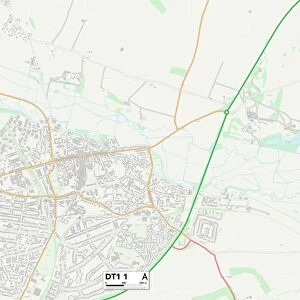
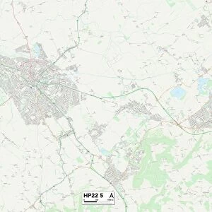
Cherwell OX25 5 Map

![]()
Wall Art and Photo Gifts from Map Marketing
Cherwell OX25 5 Map
Postcode Sector Map of Cherwell OX25 5
Media ID 19977353
Allens Lane Broad Way Camp Road Cherwell Church Lane Church Walk Cooper Close Corbett Close Cow Lane Freehold Street Gibson Drive Gordon Road Harris Road High Street Howard Road James Close Market Square Mill Lane Miller Close Nash Road Orchard Lane Orchard Place Raven Close Rectory Close Reid Place School Lane Simpson Drive Somerton Road Station Road The Lane Valley View Wellesley Close Wellington Road Williams Road Wilson Close Bourne End Fenway Heyford
FEATURES IN THESE COLLECTIONS
> Arts
> Artists
> B
> James Bourne
> Arts
> Artists
> C
> James Cooper
> Arts
> Artists
> G
> James Gibson
> Arts
> Artists
> M
> James Miller
> Arts
> Artists
> T
> James Trenchard
> Arts
> Artists
> W
> Wilson Wilson
> Europe
> United Kingdom
> England
> Cheshire
> Aston
> Europe
> United Kingdom
> England
> Cheshire
> Croft
> Europe
> United Kingdom
> England
> Cheshire
> Related Images
> Map Marketing
> Postcode Sector Maps
> OX - Oxford
> Maps and Charts
> Related Images
MADE IN THE USA
Safe Shipping with 30 Day Money Back Guarantee
FREE PERSONALISATION*
We are proud to offer a range of customisation features including Personalised Captions, Color Filters and Picture Zoom Tools
SECURE PAYMENTS
We happily accept a wide range of payment options so you can pay for the things you need in the way that is most convenient for you
* Options may vary by product and licensing agreement. Zoomed Pictures can be adjusted in the Cart.