Home > Animals > Insects > Hemiptera > Green Scale
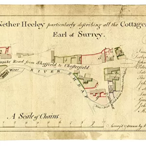
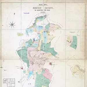
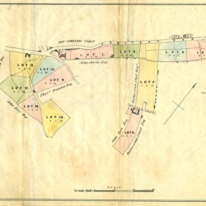
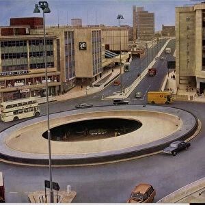
Map of Several strips and a close between Heeley Town Gate and Heeley Green, on (modern Gleadless Road), Sheffield, 1758
, Sheffield, 1758")
![]()
Wall Art and Photo Gifts from Sheffield City Archives
Map of Several strips and a close between Heeley Town Gate and Heeley Green, on (modern Gleadless Road), Sheffield, 1758
Full title: Map of several parcels of land, [the] property of [the] Duke of Norfolk and R. Gillot.
Scale [3 chains : 1 inch] [26.6 inches : 1 mile]
Surveyor: William Fairbank I.
Several strips and a close between Heeley Town Gate and Heeley Green, on (modern Gleadless Road); colours distinguish ownership; field names and acreages given on the map and listed; free land and Dukes land differentiated; mear stones and trees marked by symbols; scale on a ribbon; yellow border.
From an original at Sheffield Libraries: arc02736
Sheffield City Archives and Local Studies Library has an unrivalled collection of images of Sheffield, England
Media ID 18725120
© Sheffield City Council - All Rights Reserved
Heeley Maps Plans Sheffield Yorkshire
FEATURES IN THESE COLLECTIONS
> Animals
> Insects
> Hemiptera
> Green Scale
> Animals
> Insects
> Hemiptera
> Yellow Scale
> Europe
> France
> Canton
> Landes
> Europe
> United Kingdom
> England
> Norfolk
> Related Images
> Europe
> United Kingdom
> England
> Yorkshire
> Heeley
> Europe
> United Kingdom
> England
> Yorkshire
> Related Images
> Europe
> United Kingdom
> England
> Yorkshire
> Sheffield
> Maps and Charts
> Related Images
> Sheffield City Archives
> Maps and Plans
> Maps of Sheffield
EDITORS COMMENTS
This print takes us back in time to the year 1758, showcasing a remarkable map titled "Map of Several strips and a close between Heeley Town Gate and Heeley Green, on (modern Gleadless Road), Sheffield". The map was originally created by the skilled surveyor William Fairbank I, depicting parcels of land belonging to the Duke of Norfolk and R. Gillot. The intricate details presented in this historical artifact are truly fascinating. The use of colors distinguishes ownership, allowing viewers to discern different property boundaries at a glance. Field names and acreages are meticulously listed alongside the map, providing valuable information about each specific area. One notable feature is how free land and Dukes land are clearly differentiated on the map. Symbols marking mear stones and trees add an extra layer of visual interest while helping navigate through this ancient landscape. A scale ribbon thoughtfully placed within the composition aids in measuring distances accurately. The yellow border frames this piece beautifully, enhancing its overall aesthetic appeal. Preserved by Sheffield Libraries as arc02736, this extraordinary snapshot from Sheffield City Archives offers an invaluable glimpse into the past for those interested in maps, plans, Yorkshire history or specifically Heeley and Sheffield's development
MADE IN THE USA
Safe Shipping with 30 Day Money Back Guarantee
FREE PERSONALISATION*
We are proud to offer a range of customisation features including Personalised Captions, Color Filters and Picture Zoom Tools
SECURE PAYMENTS
We happily accept a wide range of payment options so you can pay for the things you need in the way that is most convenient for you
* Options may vary by product and licensing agreement. Zoomed Pictures can be adjusted in the Cart.