Home > Maps and Charts > Abraham Ortelius
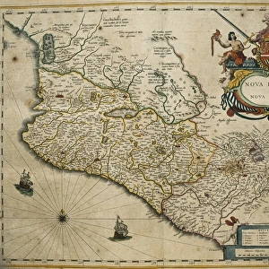
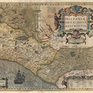
Theatrum Orbis Terrarum. New Spain (Mexico)
")
![]()
Wall Art and Photo Gifts from Mary Evans Picture Library
Theatrum Orbis Terrarum. New Spain (Mexico)
ORTELIUS, Abraham (1527-1598). Theatrum Orbis Terrarum. 1570. It is considered to be the first modern atlas. Map of New Spain (Mexico), 1579. Printed in Antwerp by Christophe Plantin (1588). Etching. SPAIN. CASTILE AND LEON. Salamanca. Salamanca University Library
Mary Evans Picture Library makes available wonderful images created for people to enjoy over the centuries
Media ID 14181320
© J. Bedmar/Iberfoto/Mary Evans
1527 1570 1579 1588 1598 Abraham Antwerp Atlas Cartographic Cartographies Cartography Castile Christophe Colonization Colonize Considered Craft Crafts Engravings Etching Etchings Geogr Ficas Geogr Ficos Geograf Geografia Geografica Geografico Geogrl9 Ca Geogrl9 Cas Geogrl9 Co Geogrl9 Cos Leon Maps Mexico Orbis Ortelius Plantin Salamanca Terrarum Theatrum University Viceroyalty
EDITORS COMMENTS
This image showcases the intricately detailed map of New Spain, or Mexico, as it appeared in the seminal work of cartography, "Theatrum Orbis Terrarum," published by the renowned Flemish cartographer Abraham Ortelius in 1570. Considered the first modern atlas, this masterpiece was printed in Antwerp by Christophe Plantin in 1588. The map, dated to 1579, is an etching that offers a fascinating glimpse into the geographical knowledge of the time. The map is replete with intricate details, including the depiction of various boats and ships, suggesting the importance of maritime trade and exploration during the era of Spanish colonization. The map also highlights the territories under the rule of the Viceroyalty of New Spain, which extended from present-day Mexico to Central America. The map's creation was a significant achievement for cartography, as it marked a departure from the traditional, fragmented approach to mapmaking and instead presented a comprehensive, cohesive representation of the world's known territories. This map, along with the other maps in "Theatrum Orbis Terrarum," served as an essential tool for navigators, explorers, and scholars, shaping our understanding of the world during the Age of Discovery. This particular map, housed in the Salamanca University Library in Spain, is a testament to the enduring importance of cartography in the exploration and documentation of the world. Its intricate details and historical significance make it a must-see for anyone interested in the history of cartography, geography, or the Age of Discovery.
MADE IN THE USA
Safe Shipping with 30 Day Money Back Guarantee
FREE PERSONALISATION*
We are proud to offer a range of customisation features including Personalised Captions, Color Filters and Picture Zoom Tools
SECURE PAYMENTS
We happily accept a wide range of payment options so you can pay for the things you need in the way that is most convenient for you
* Options may vary by product and licensing agreement. Zoomed Pictures can be adjusted in the Cart.