Home > Arts > Contemporary art > Digital artwork > Street art
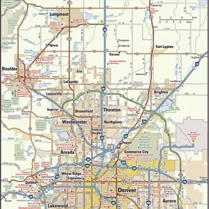
MA Franklin Rowe Vector Road Map

![]()
Wall Art and Photo Gifts from Fine Art Storehouse
MA Franklin Rowe Vector Road Map
MA Franklin Rowe Vector Road Map. All source data is in the public domain. U.S. Census Bureau Census Tiger. Used Layers: areawater, linearwater, roads, rails, cousub, pointlm, uac10
Unleash your creativity and transform your space into a visual masterpiece!
Frank Ramspott
Media ID 20689761
© Frank Ramspott, all rights reserved
City Map Computer Graphic County Dell Digital Composite District Franklin Geographical Border Massachusetts Road Map Text Vector Digitally Generated Image Rowe Zoar
FEATURES IN THESE COLLECTIONS
> Animals
> Mammals
> Cats (Wild)
> Tiger
> Animals
> Mammals
> Muridae
> Water Mouse
> Arts
> Contemporary art
> Digital artwork
> Street art
> Arts
> Landscape paintings
> Waterfall and river artworks
> River artworks
> Arts
> Portraits
> Pop art gallery
> Street art portraits
> Arts
> Street art graffiti
> Digital art
> Digital paintings
> Fine Art Storehouse
> Map
> Reference Maps
> Maps and Charts
> Related Images
> Popular Themes
> Lake District
EDITORS COMMENTS
This print showcases the MA Franklin Rowe Vector Road Map, a masterpiece of cartography and design. Created by Frank Ramspott, this digitally generated image is a testament to his skill in creating visually stunning and informative maps. The map incorporates various layers sourced from the public domain, including areawater, linearwater, roads, rails, cousub, pointlm, and uac10 data from the U. S. Census Bureau Census Tiger. With its vibrant colors and precise detailing, it provides an accurate representation of Massachusetts' physical geography. While devoid of people or any human presence, this color image beautifully captures the geographical borders of cities and towns within Massachusetts. From Monroe Bridge to Adams Mountain and Dell to Zoar - every landmark is meticulously depicted with clarity. Rivers meander gracefully across the landscape while lakes shimmer under the sun's gentle rays. The intricate network of streets weaves through each city like veins connecting vital organs. Text labels guide us through this visual journey as we navigate our way around Franklin County. As a digital composite created using vector technology, this artwork seamlessly blends artistry with scientific accuracy. It serves as both an aesthetic delight for admirers of fine art prints and a practical tool for those seeking guidance on their travels throughout Massachusetts
MADE IN THE USA
Safe Shipping with 30 Day Money Back Guarantee
FREE PERSONALISATION*
We are proud to offer a range of customisation features including Personalised Captions, Color Filters and Picture Zoom Tools
SECURE PAYMENTS
We happily accept a wide range of payment options so you can pay for the things you need in the way that is most convenient for you
* Options may vary by product and licensing agreement. Zoomed Pictures can be adjusted in the Cart.