Home > Europe > United Kingdom > Scotland > Related Images
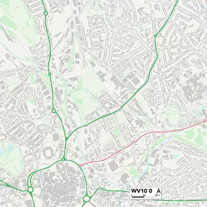
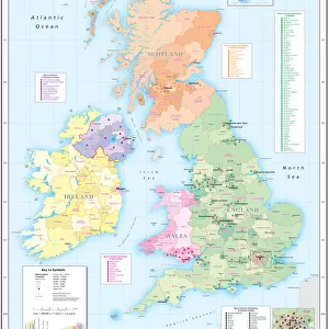
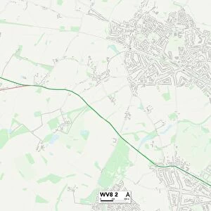
Wolverhampton WV10 8 Map

![]()
Wall Art and Photo Gifts from Map Marketing
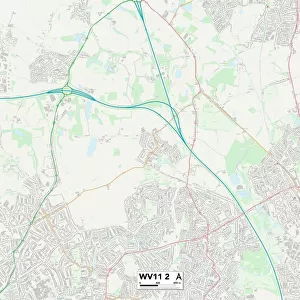
Wolverhampton WV10 8 Map
Postcode Sector Map of Wolverhampton WV10 8
Media ID 19983362
Ainsworth Road Alton Close Bentley Road Broadway Burns Avenue Byron Road Cannock Road Carisbrooke Road Carlyle Road Chartwell Drive Chesterton Road Collingwood Road Croft Lane Cromwell Road Dickens Road Dryden Road Egerton Road Elton Close Emerson Road Fairfax Road Grassy Lane Greenfield Lane Grosvenor Close Grosvenor Crescent Grosvenor Road Hamilton Gardens Heaton Close Highfield Avenue Keats Grove Keats Road Larkin Close Lincoln Green Masefield Road Moreton Road New Road Newman Road Pear Tree Lane Primrose Avenue Primrose Lane Rudyard Close Ruskin Road Sandy Lane School Lane St Chads Road Tennyson Road The Riddings Underhill Underhill Lane Wentworth Road Westcroft Wolverhampton Wood Lane Wordsworth Road Scotlands
FEATURES IN THESE COLLECTIONS
> Africa
> Chad
> Related Images
> Animals
> Birds
> Passerines
> Whistlers
> Related Images
> Animals
> Mammals
> Cats (Domestic)
> Scottish Fold
> Europe
> United Kingdom
> Scotland
> Maps
> Europe
> United Kingdom
> Scotland
> Related Images
> Europe
> United Kingdom
> Scotland
> Strathclyde
> Hamilton
> Map Marketing
> Postcode Sector Maps
> WV - Wolverhampton
> Maps and Charts
> Related Images
MADE IN THE USA
Safe Shipping with 30 Day Money Back Guarantee
FREE PERSONALISATION*
We are proud to offer a range of customisation features including Personalised Captions, Color Filters and Picture Zoom Tools
SECURE PAYMENTS
We happily accept a wide range of payment options so you can pay for the things you need in the way that is most convenient for you
* Options may vary by product and licensing agreement. Zoomed Pictures can be adjusted in the Cart.