Home > North America > United States of America > Maps
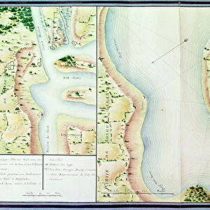
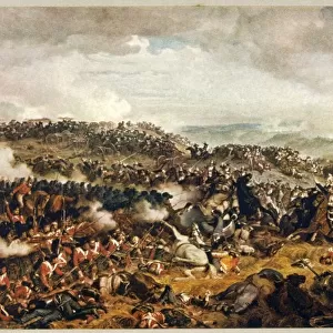
General map of the camps and marche of the army in America on the orders of Rochambeau

![]()
Wall Art and Photo Gifts from Fine Art Finder
General map of the camps and marche of the army in America on the orders of Rochambeau
XIR440788 General map of the camps and marche of the army in America on the orders of Rochambeau, detail of the left side, from Guerre de l Amerique, c.1780-81 (colour engraving) (see also 440787) by Dubourg, F. (fl.1780-82); Service Historique de la Marine, Vincennes, France; (add.info.: Jean-Baptiste de Vimeur (1725-1807) Count of Rochambeau; ); French, out of copyright
Media ID 18256163
© Service Historique de la Marine, Vincennes, France / Bridgeman Images
American War Of Independence Camps Chesapeake Bay Encampment Encampments Journeys Maryland Orders Revolutionary War Rochambeau
FEATURES IN THESE COLLECTIONS
> Fine Art Finder
> Artists
> F. Dubourg
> Maps and Charts
> Related Images
> North America
> United States of America
> Delaware
> Related Images
> North America
> United States of America
> Maps
> North America
> United States of America
> Maryland
> Related Images
EDITORS COMMENTS
This print showcases a detailed map titled "General Map of the Camps and Marche of the Army in America on the Orders of Rochambeau". Created by French cartographer F. Dubourg around 1780-81, this color engraving provides an invaluable glimpse into the American War of Independence. The left side detail highlights various aspects of this historical journey. It vividly depicts the coastal regions, including Delaware Bay and Chesapeake Bay, where crucial military movements took place during this period. The encampments and campsites are meticulously marked, offering insight into the strategic positioning of troops under General Jean-Baptiste de Vimeur, Count of Rochambeau. As one delves deeper into this remarkable artwork, it becomes evident that every element has been thoughtfully portrayed to convey both geographical accuracy and historical significance. The map serves as a testament to Rochambeau's leadership and his pivotal role in supporting American forces against British rule. Preserved at Service Historique de la Marine in Vincennes, France, this piece represents an essential resource for scholars studying the Revolutionary War era. Its rich details not only provide valuable insights into troop movements but also evoke a sense of awe for those who appreciate cartography as an art form. Through its intricate depiction of coastlines, encampments, and orders given by Rochambeau himself, this extraordinary map offers viewers a window into history—an opportunity to witness firsthand how these brave soldiers navigated through challenging terrain to fight
MADE IN THE USA
Safe Shipping with 30 Day Money Back Guarantee
FREE PERSONALISATION*
We are proud to offer a range of customisation features including Personalised Captions, Color Filters and Picture Zoom Tools
SECURE PAYMENTS
We happily accept a wide range of payment options so you can pay for the things you need in the way that is most convenient for you
* Options may vary by product and licensing agreement. Zoomed Pictures can be adjusted in the Cart.