Home > Maps and Charts > Africa
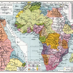
Treaty Map of Africa (engraving)
")
![]()
Wall Art and Photo Gifts from Fine Art Finder
Treaty Map of Africa (engraving)
1606524 Treaty Map of Africa (engraving) by English School, (19th century); Private Collection; (add.info.: Treaty Map of Africa. Illustration for The Illustrated London News, 24 September 1898.
English School (19th Century)); Look and Learn / Illustrated Papers Collection
Media ID 22265120
© Look and Learn / Illustrated Papers Collection / Bridgeman Images
FEATURES IN THESE COLLECTIONS
> Africa
> Related Images
> Fine Art Finder
> Artists
> English Photographer
> Fine Art Finder
> Artists
> English School
> Maps and Charts
> Related Images
EDITORS COMMENTS
This print showcases the intricate "Treaty Map of Africa (engraving)" created by an English School in the 19th century. The map, now part of a private collection, offers a fascinating glimpse into the historical agreements and boundaries that shaped Africa during this era. With its meticulous details and precise engravings, this map serves as a visual representation of the numerous treaties signed across the continent. Each line and symbol on the map signifies a significant agreement between different nations or colonial powers, illustrating how Africa was divided among various European countries. The significance of this treaty map is further emphasized by its publication in The Illustrated London News on September 24th, 1898. As one examines this piece closely, it becomes apparent that it not only provides valuable geographical information but also sheds light on the complex political dynamics at play during that time. The inclusion of this engraving within Look and Learn / Illustrated Papers Collection highlights its importance as an educational resource for those seeking to understand African history from a global perspective. Bridgeman Images has expertly preserved this remarkable artwork through their fine art finder platform, allowing viewers to appreciate both its aesthetic beauty and historical significance. In summary, this print captures an extraordinary Treaty Map of Africa engraving from the 19th century—an invaluable artifact that encapsulates both geographical knowledge and geopolitical complexities prevalent during that period.
MADE IN THE USA
Safe Shipping with 30 Day Money Back Guarantee
FREE PERSONALISATION*
We are proud to offer a range of customisation features including Personalised Captions, Color Filters and Picture Zoom Tools
SECURE PAYMENTS
We happily accept a wide range of payment options so you can pay for the things you need in the way that is most convenient for you
* Options may vary by product and licensing agreement. Zoomed Pictures can be adjusted in the Cart.