Home > Europe > United Kingdom > Scotland > Stirlingshire > Stirling
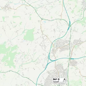
West Dunbartonshire G83 8 Map

![]()
Wall Art and Photo Gifts from Map Marketing
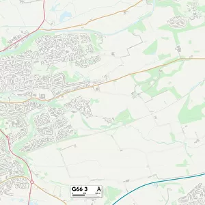
West Dunbartonshire G83 8 Map
Postcode Sector Map of West Dunbartonshire G83 8
Media ID 19970761
Barton Avenue Brooke Avenue Brown Street Buchanan Court Burnside Crescent Carson Road Castle Avenue Church Road Cook Road Davidson Road Glen Avenue Honeysuckle Lane Lawrence Drive Lomond Road Main Street Manse Court Manse Gardens Martin Avenue Miller Place Miller Road Murray Place Old Military Road Old School Road Park Avenue Pier Road Riverside Riverside Gardens School Road Smith Crescent South Avenue Stirling Road Talbot Road West Dunbartonshire Woodburn Avenue Arden Balloch Jamestown Luss
FEATURES IN THESE COLLECTIONS
> Animals
> Mammals
> Dogs (Wild)
> Red Fox
> Animals
> Mammals
> Muridae
> Peters Mouse
> Europe
> United Kingdom
> Scotland
> Stirlingshire
> Stirling
> Map Marketing
> Postcode Sector Maps
> G - Glasgow
> Maps and Charts
> Related Images
MADE IN THE USA
Safe Shipping with 30 Day Money Back Guarantee
FREE PERSONALISATION*
We are proud to offer a range of customisation features including Personalised Captions, Color Filters and Picture Zoom Tools
SECURE PAYMENTS
We happily accept a wide range of payment options so you can pay for the things you need in the way that is most convenient for you
* Options may vary by product and licensing agreement. Zoomed Pictures can be adjusted in the Cart.