Home > Arts > Landscape paintings > Waterfall and river artworks > River artworks
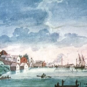
FORT DETROIT, 1749. Map of Fort Detroit based on a drawing by Joseph Gaspard Chaussegros

![]()
Wall Art and Photo Gifts from Granger
FORT DETROIT, 1749. Map of Fort Detroit based on a drawing by Joseph Gaspard Chaussegros
FORT DETROIT, 1749.
Map of Fort Detroit based on a drawing by Joseph Gaspard Chaussegros de Le Roy, a French Army engineer, 1749
Granger holds millions of images spanning more than 25,000 years of world history, from before the Stone Age to the dawn of the Space Age
Media ID 12226255
1749 American Indian Army Canoe Colonial Detroit Engineer Fort Fort Detroit French Indian War Frontier Gaspard Joseph Trading Post United States
FEATURES IN THESE COLLECTIONS
> Arts
> Landscape paintings
> Waterfall and river artworks
> River artworks
> Granger Art on Demand
> American History
> Historic
> Colonial America illustrations
> Colonial America
> Maps and Charts
> Related Images
> North America
> Related Images
FORT DETROIT, 1749 - A Glimpse into the Colonial Frontier
EDITORS COMMENTS
. This print takes us back to the year 1749, offering a rare glimpse into the historical significance of Fort Detroit. Based on an intricate drawing by Joseph Gaspard Chaussegros de Le Roy, a renowned French Army engineer, this map showcases the strategic layout and architectural details of the fort. Nestled in what is now known as Michigan, Fort Detroit played a crucial role during the French Indian War era. The image depicts an exterior view of the fort, revealing its sturdy walls and watchtowers that guarded against potential threats from both American Indians and rival European powers. The presence of canoes along the river signifies how vital waterways were for transportation and trade in those times. This trading post served as a hub for interactions between various cultures - American Indian tribes, French settlers, and British colonists - all seeking their fortunes in this vast North American continent. As we admire this meticulously crafted map print, let us reflect on how it represents not only a physical structure but also symbolizes resilience and determination amidst challenging circumstances. It serves as a reminder of our shared history and heritage that shaped what would eventually become one of the great cities in modern-day United States – Detroit.
MADE IN THE USA
Safe Shipping with 30 Day Money Back Guarantee
FREE PERSONALISATION*
We are proud to offer a range of customisation features including Personalised Captions, Color Filters and Picture Zoom Tools
SECURE PAYMENTS
We happily accept a wide range of payment options so you can pay for the things you need in the way that is most convenient for you
* Options may vary by product and licensing agreement. Zoomed Pictures can be adjusted in the Cart.