Home > North America > United States of America > New York > New York > Maps
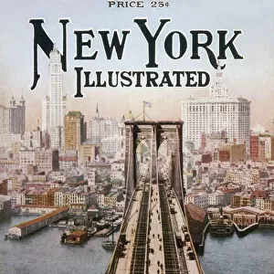
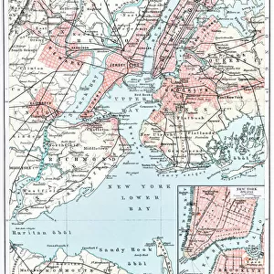
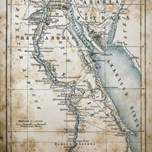
Map of New York city 1896

![]()
Wall Art and Photo Gifts from Fine Art Storehouse
Map of New York city 1896
Ilustration of a Map of New York city 1896
Unleash your creativity and transform your space into a visual masterpiece!
Nastasic
Media ID 13750439
© This content is subject to copyright
1896 Backgrounds Brooklyn New York Grunge Image Technique New Jersey New York City New York State Paper Patina Serbia Textured Effect Hoboken Obsolete
FEATURES IN THESE COLLECTIONS
> Europe
> Serbia
> Related Images
> Fine Art Storehouse
> Map
> Historical Maps
> Fine Art Storehouse
> Map
> USA Maps
> Maps and Charts
> Related Images
> North America
> United States of America
> Maps
> North America
> United States of America
> New Jersey
> Jersey City
> North America
> United States of America
> New Jersey
> Related Images
> North America
> United States of America
> New York
> New York
> Brooklyn
> Related Images
> North America
> United States of America
> New York
> New York
> Maps
EDITORS COMMENTS
This print takes us back in time to the bustling streets of New York City in 1896. The map, beautifully illustrated with intricate details, showcases the city's various boroughs and neighborhoods. The vertical composition adds a unique perspective, allowing us to immerse ourselves in this historical moment. The grunge image technique used here gives the print an authentic vintage feel, as if it has been weathered by time itself. It transports us to an era when paper maps were essential for navigating through the labyrinthine streets of this iconic metropolis. The engraving technique employed further enhances the charm of this artwork, highlighting every street and landmark with precision and artistry. The patina effect adds a touch of nostalgia, reminding us that this map is not just a representation but also a piece of history. As we examine this old cartography masterpiece closely, we can almost imagine horse-drawn carriages traversing Brooklyn or ferries shuttling between Hoboken and Manhattan. This illustration captures a snapshot of physical geography frozen in time. With its textured effect and obsolete yet enduring appeal, Nastasic's Map of New York City 1896 serves as both an artistic treasure and a valuable historical artifact. It allows us to appreciate how much our beloved city has evolved over more than a century while preserving its timeless allure.
MADE IN THE USA
Safe Shipping with 30 Day Money Back Guarantee
FREE PERSONALISATION*
We are proud to offer a range of customisation features including Personalised Captions, Color Filters and Picture Zoom Tools
SECURE PAYMENTS
We happily accept a wide range of payment options so you can pay for the things you need in the way that is most convenient for you
* Options may vary by product and licensing agreement. Zoomed Pictures can be adjusted in the Cart.