Home > Arts > Artists > C > Samuel de Champlain
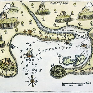
MAP: PORT ST. LOUIS, 1605. Samuel de Champlains map of Port St

![]()
Wall Art and Photo Gifts from Granger
MAP: PORT ST. LOUIS, 1605. Samuel de Champlains map of Port St
MAP: PORT ST. LOUIS, 1605.
Samuel de Champlains map of Port St. Louis, later settled by the English as Plymoth, Massachusetts, drawn during an expedition of 1605
Granger holds millions of images spanning more than 25,000 years of world history, from before the Stone Age to the dawn of the Space Age
Media ID 12568329
1605 Champlain Colony Exploration Harbor Pilgrim Plymouth Samuel Settlement Topography United States Wampanoag
FEATURES IN THESE COLLECTIONS
> Arts
> Artists
> C
> Samuel de Champlain
> Granger Art on Demand
> U.S. States
> Maps and Charts
> Related Images
EDITORS COMMENTS
This print showcases Samuel de Champlain's map of Port St. Louis, drawn during his expedition in 1605. The intricate details and topography depicted on the map provide a fascinating glimpse into the early exploration and settlement of North America. Port St. Louis, later known as Plymouth, Massachusetts, holds immense historical significance as one of the first English colonies established in America. This map serves as a visual testament to the beginnings of this iconic settlement. As we delve into this piece, we are transported back in time to an era when Native American tribes like the Wampanoag inhabited these lands alongside European explorers and settlers. The convergence of cultures is palpable through Champlain's depiction of Indian villages along the river. The woodcut style adds a rustic charm to this print, further enhancing its nostalgic appeal. It invites us to ponder upon the challenges faced by those who embarked on these expeditions centuries ago. Whether you are an avid history enthusiast or simply appreciate art that tells stories from our past, this print is sure to captivate your imagination and spark curiosity about America's colonial heritage.
MADE IN THE USA
Safe Shipping with 30 Day Money Back Guarantee
FREE PERSONALISATION*
We are proud to offer a range of customisation features including Personalised Captions, Color Filters and Picture Zoom Tools
SECURE PAYMENTS
We happily accept a wide range of payment options so you can pay for the things you need in the way that is most convenient for you
* Options may vary by product and licensing agreement. Zoomed Pictures can be adjusted in the Cart.