Home > Arts > Landscape paintings > Waterfall and river artworks > River artworks
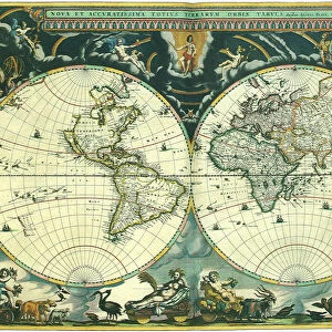
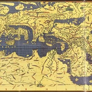
WORLD MAP, c1300. Map, late 19th century, depicting the extent of knowledge of the worlds geography c1300, and including the route of Marco Polos return voyage from China

![]()
Wall Art and Photo Gifts from Granger
WORLD MAP, c1300. Map, late 19th century, depicting the extent of knowledge of the worlds geography c1300, and including the route of Marco Polos return voyage from China
WORLD MAP, c1300. Map, late 19th century, depicting the extent of knowledge of the worlds geography c1300, and including the route of Marco Polos return voyage from China in 1292
Granger holds millions of images spanning more than 25,000 years of world history, from before the Stone Age to the dawn of the Space Age
Media ID 6616407
1300 Exploration Mappa Mundi Mark Polo World
FEATURES IN THESE COLLECTIONS
> Arts
> Art Movements
> Medieval Art
> Arts
> Landscape paintings
> Waterfall and river artworks
> River artworks
> Granger Art on Demand
> Maps
> Maps and Charts
> Related Images
> Maps and Charts
> World
EDITORS COMMENTS
This print showcases a remarkable piece of history - the "WORLD MAP, c1300". Created in the late 19th century, this map depicts the extent of knowledge regarding global geography during the 14th century. It offers a fascinating glimpse into how people perceived and understood the world at that time. The map not only displays various continents and countries but also highlights significant exploration journeys undertaken during this period. One notable route depicted is that of Marco Polo's return voyage from China in 1292. This adds an exciting dimension to the artwork as it represents one of history's most renowned explorers and his incredible adventures. As we delve into this medieval treasure trove, we are transported back to a time when cartography was still evolving. The intricate details and delicate craftsmanship on display demonstrate both artistic skill and scientific curiosity prevalent during this era. The inclusion of rivers throughout the map further emphasizes its significance as waterways played a vital role in trade routes, transportation, and communication networks during medieval times. Overall, this stunning print from The Granger Collection serves as a visual testament to humanity's thirst for knowledge and exploration. It invites us to reflect on our ancestors' efforts to understand their place in an ever-expanding world while reminding us of our own ongoing journey towards discovery and understanding.
MADE IN THE USA
Safe Shipping with 30 Day Money Back Guarantee
FREE PERSONALISATION*
We are proud to offer a range of customisation features including Personalised Captions, Color Filters and Picture Zoom Tools
SECURE PAYMENTS
We happily accept a wide range of payment options so you can pay for the things you need in the way that is most convenient for you
* Options may vary by product and licensing agreement. Zoomed Pictures can be adjusted in the Cart.