Home > Europe > United Kingdom > England > London > Towns > Wood Green
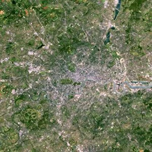
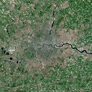
London, UK, satellite image

![]()
Wall Art and Photo Gifts from Science Photo Library
London, UK, satellite image
London, UK. Satellite image of the city of London (centre) and its surrounding area. North is at top. The River Thames is seen running through the city from left to right. Forested areas are dark green, agricultural fields are lighter shades of green and brown, urban areas are grey, and water is black. Image created using NaturalVue data obtained from the Landsat 7 satellite
Science Photo Library features Science and Medical images including photos and illustrations
Media ID 1704991
© EARTH SATELLITE CORPORATION/SCIENCE PHOTO LIBRARY
Capital City Earth Observation Farm Land Field Fields Forest Forests From Space Greater London Landsat 7 Nasa Natural Colour Naturalvue River River Thames Satellite Satellite Image Urban Urbanisation Urbanization Vegetation Wood Land
FEATURES IN THESE COLLECTIONS
> Animals
> Mammals
> Muridae
> Water Mouse
> Arts
> Landscape paintings
> Forest and woodland scenes
> Forest artwork
> Arts
> Landscape paintings
> Waterfall and river artworks
> River artworks
> Europe
> France
> Canton
> Landes
> Europe
> Related Images
> Europe
> United Kingdom
> England
> Greater London
> Related Images
> Europe
> United Kingdom
> England
> Greater London
> Wood Green
> Europe
> United Kingdom
> England
> London
> Museums
> British Library
> Europe
> United Kingdom
> England
> London
> River Thames
> Europe
> United Kingdom
> England
> London
> Towns
> Wood Green
> Science Photo Library
> Aerial and Satellite
EDITORS COMMENTS
This print showcases a satellite image of the vibrant city of London, UK. The image captures the heart of the city, with its iconic River Thames flowing gracefully from left to right. As we explore this aerial view, we can distinguish various features that define London's diverse landscape. The dark green patches represent lush forests, while lighter shades of green and brown indicate agricultural fields dotting the outskirts. Urban areas are depicted in shades of grey, symbolizing the bustling metropolis that is London. The black hue represents water bodies scattered throughout the region. Created using NaturalVue data obtained from NASA's Landsat 7 satellite, this remarkable image offers an extraordinary perspective on England's capital city. It allows us to appreciate both its natural beauty and impressive urbanization. From space, one can truly grasp Greater London's vastness and understand how it seamlessly blends nature with human habitation. This photograph not only highlights geographical elements but also emphasizes the importance of preserving these delicate ecosystems amidst rapid urban development. Courtesy of Science Photo Library, this stunning satellite image serves as a testament to our ability to observe Earth from above and gain valuable insights into our planet's ever-changing landscapes.
MADE IN THE USA
Safe Shipping with 30 Day Money Back Guarantee
FREE PERSONALISATION*
We are proud to offer a range of customisation features including Personalised Captions, Color Filters and Picture Zoom Tools
SECURE PAYMENTS
We happily accept a wide range of payment options so you can pay for the things you need in the way that is most convenient for you
* Options may vary by product and licensing agreement. Zoomed Pictures can be adjusted in the Cart.