Home > Europe > France > Canton > Landes
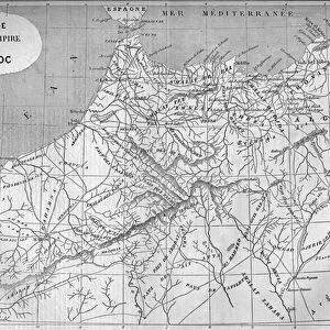
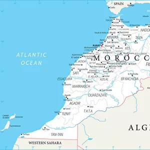
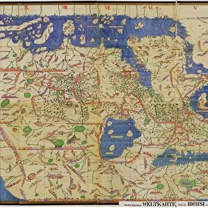
Map of Morocco, 1601

![]()
Wall Art and Photo Gifts from Mary Evans Picture Library
Map of Morocco, 1601
Map of Morocco, north, africa, african, 1601.
1601
Mary Evans Picture Library makes available wonderful images created for people to enjoy over the centuries
Media ID 23058614
© Mary Evans Picture Library
1600s 1601 Cartography Coastline Gulf Latin Mares Morocco Sahara Territory Numidia
FEATURES IN THESE COLLECTIONS
> Africa
> Morocco
> Related Images
> Africa
> Related Images
> Europe
> France
> Canton
> Landes
> Europe
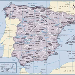
> Spain
> Related Images
> Maps and Charts
> Related Images
> Maps and Charts
> Spain
> Mary Evans Prints Online
> New Images August 2021
EDITORS COMMENTS
This map print, dating back to the year 1601, showcases an intricate and detailed representation of Morocco's geography during the 17th century. The map, titled "Map of Morocco, north Africa," offers a glimpse into the cartographic knowledge of the time, with a focus on the northern regions of the country. The map is adorned with various features that reflect the political and geographical landscape of Morocco during this era. The coastal regions are prominently featured, with the Atlantic Ocean and the Mediterranean Sea depicted with remarkable accuracy. The map also highlights the gulfs of Cádiz and Almería, which were significant points of contact between Morocco and Europe during this period. The map also reveals the territorial claims of various European powers, with the Spanish dominion extending over parts of the coastline. The Sahara desert is also depicted, with the territory of Numidia, a historical region in northern Africa, shown to the south of the map. The map is rich in detail, with various place names and geographical features labeled in both Latin and Spanish, reflecting the multicultural influences of the time. The map also includes illustrations of horses, or 'yeguas,' and 'mares,' which may represent settlements or fortifications. This map is a testament to the advancements in cartography during the 1600s and provides valuable insights into the political and geographical landscape of Morocco during this period. It is a fascinating historical artifact that offers a unique perspective into the world of exploration and discovery during the Age of Discovery.
MADE IN THE USA
Safe Shipping with 30 Day Money Back Guarantee
FREE PERSONALISATION*
We are proud to offer a range of customisation features including Personalised Captions, Color Filters and Picture Zoom Tools
SECURE PAYMENTS
We happily accept a wide range of payment options so you can pay for the things you need in the way that is most convenient for you
* Options may vary by product and licensing agreement. Zoomed Pictures can be adjusted in the Cart.