Home > Europe > United Kingdom > England > London > Towns > Docklands
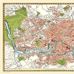
Old Street Map of Woolwich and Thames Docklands 1908

![]()
Wall Art and Photo Gifts from MapSeeker
Old Street Map of Woolwich and Thames Docklands 1908
Detailed colour Street Plan of London from 1908 covering the area around Woolwich and the Thames Docklands.The image has been remastered from Bartholomews Handy Atlas of London and Suburbs 1908
Welcome to the Mapseeker Image library and enter an historic gateway to one of the largest on-line collections of Historic Maps, Nostalgic Views, Vista's and Panorama's from a World gone by.
Media ID 20347769
© Mapseeker Publishing Ltd, Collins Bartholomew Ltd
London Map London Street Plan Map Of Central London Map Of London Old London Street Map Old Map Of London Central Street Map Of London Street Plan Woolwich
FEATURES IN THESE COLLECTIONS
> Arts
> Photorealistic artworks
> Detailed art pieces
> Masterful detailing in art
> Europe
> United Kingdom
> England
> London
> River Thames
> Europe
> United Kingdom
> England
> London
> Towns
> Docklands
> Europe
> United Kingdom
> England
> London
> Towns
> Woolwich
> Maps and Charts
> Related Images
> MapSeeker
> British Town And City Plans
> English & Welsh PORTFOLIO
EDITORS COMMENTS
This print takes us back in time to the bustling streets of Woolwich and the Thames Docklands in 1908. The detailed colour street plan of London from that era showcases the rich history and development of this vibrant area. Remastered from Bartholomews Handy Atlas of London and Suburbs, this image offers a glimpse into the past with its intricate cartography. As we explore this old map, we can't help but be amazed by how much has changed over the years. Every street, building, and landmark tells a story of a bygone era. From the narrow lanes to the grand avenues, it's fascinating to see how people navigated through these streets more than a century ago. The River Thames flows majestically through this historical landscape, serving as both a lifeline for trade and transportation. The Thames Docklands come alive on this map, showcasing their importance as hubs for commerce and industry during that time. John Bartholomew's expertise shines through in his meticulous attention to detail captured in every corner of this print. Collins BartholomewMapseeker Publishing has done an exceptional job preserving this piece of history for us to admire today. Whether you're an avid historian or simply curious about London's past, this old street map is sure to transport you back in time. It serves as a reminder of how cities evolve while still retaining traces of their heritage.
MADE IN THE USA
Safe Shipping with 30 Day Money Back Guarantee
FREE PERSONALISATION*
We are proud to offer a range of customisation features including Personalised Captions, Color Filters and Picture Zoom Tools
SECURE PAYMENTS
We happily accept a wide range of payment options so you can pay for the things you need in the way that is most convenient for you
* Options may vary by product and licensing agreement. Zoomed Pictures can be adjusted in the Cart.