Home > Arts > Photorealistic artworks > Detailed art pieces > Masterful detailing in art
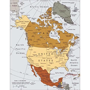
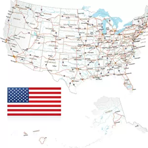
North America map

![]()
Wall Art and Photo Gifts from Fine Art Storehouse
North America map
Vector illustration of a detailed map of North America.
Reference map was created by the US Central Intelligence Agency and is available as a public domain map at the University of Texas Libraries website.
http://www.lib.utexas.edu/maps/americas/north_america_ref_2010.pdf
Software used in the creation of the map is Adobe Illustrator CC
Unleash your creativity and transform your space into a visual masterpiece!
calvindexter
Media ID 18830119
Alaska Us State Arctic Ocean Atlantic Ocean Backgrounds Business Canada Central America Concepts And Topics Cuba Data Design Element Destination Division Education Geographical Border Geographical Locations Global Communications Greenland Gulf Of Mexico Ideas Infographic International Border Land Landmark Mexico Navigational Equipment North America Outline Pacific Ocean Rocky Mountains Sign Silhouette Symbol Technology The Americas The Media Topography Unity Vector Washington Dc Appalachian Mountains Social Media
FEATURES IN THESE COLLECTIONS
> Arts
> Artists
> O
> Oceanic Oceanic
> Arts
> Photorealistic artworks
> Detailed art pieces
> Masterful detailing in art
> Europe
> France
> Canton
> Landes
> Fine Art Storehouse
> Map
> Reference Maps
> Fine Art Storehouse
> Map
> USA Maps
> Historic
> Monuments and landmarks
> Maps and Charts
> Related Images
> North America
> Canada
> Maps
> North America
> Canada
> Related Images
> North America
> Cuba
> Maps
> North America
> Cuba
> Related Images
EDITORS COMMENTS
This print showcases a meticulously detailed map of North America, rendered in vector illustration. The reference map used as the foundation for this artwork was thoughtfully crafted by the US Central Intelligence Agency and is now available as a public domain resource at the University of Texas Libraries website. Created using Adobe Illustrator CC software, this map encompasses not only the United States, Canada, and Mexico but also highlights other significant geographical features such as Central America, Alaska (a US state), Greenland, Cuba, and various bodies of water including the Atlantic Ocean, Pacific Ocean, Gulf of Mexico, and Arctic Ocean. The inclusion of navigational equipment symbolizes global communications while iconic landmarks like Washington DC's silhouette represent cultural significance. This image serves as an educational tool that beautifully combines elements from business to technology to social media. It evokes ideas surrounding unity and division within diverse cultures while providing valuable data on physical geography. With its vibrant colors and clean design elements, this visually striking print is perfect for anyone interested in cartography or exploring different destinations across North America. Whether displayed in homes or offices alike, it serves as a reminder of our interconnected world and invites viewers to embark on their own journeys through this vast continent filled with rich history and natural wonders.
MADE IN THE USA
Safe Shipping with 30 Day Money Back Guarantee
FREE PERSONALISATION*
We are proud to offer a range of customisation features including Personalised Captions, Color Filters and Picture Zoom Tools
SECURE PAYMENTS
We happily accept a wide range of payment options so you can pay for the things you need in the way that is most convenient for you
* Options may vary by product and licensing agreement. Zoomed Pictures can be adjusted in the Cart.