Home > Arts > Artists > W > Wilson Wilson
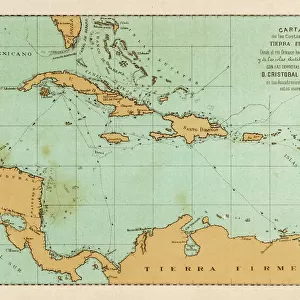
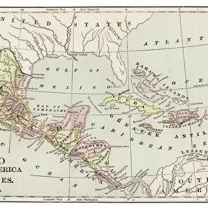
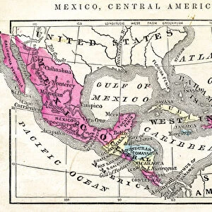
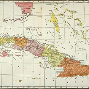
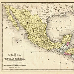
Map of Mexico Central America of 1877

![]()
Wall Art and Photo Gifts from Fine Art Storehouse
Map of Mexico Central America of 1877
The Eclectic Elementary Geography by Wilson & Hinkle / Cincinnati -New York 1881
Unleash your creativity and transform your space into a visual masterpiece!
THEPALMER
Media ID 15256735
© This content is subject to copyright
Caribbean Central America Cuba Dominican Republic Honduras Mexico Nicaragua Panama Puerto Rico West Indies
FEATURES IN THESE COLLECTIONS
> Arts
> Artists
> W
> Wilson Wilson
> Fine Art Storehouse
> Map
> Historical Maps
> Maps and Charts
> Related Images
> North America
> Cuba
> Maps
> North America
> Cuba
> Related Images
> North America
> Dominican Republic
> Maps
> North America
> Dominican Republic
> Related Images
> North America
> Honduras
> Maps
> North America
> Honduras
> Related Images
> North America
> Mexico
> Related Images
EDITORS COMMENTS
In this photo print, we are transported back in time to the year 1877, as we explore a meticulously detailed "Map of Mexico Central America". This historical artifact was originally featured in "The Eclectic Elementary Geography" by Wilson & Hinkle and published in Cincinnati-New York in 1881. The map showcases not only the geographical wonders of Mexico and Central America but also includes the Antillas, Cuba, West Indies, Caribbean islands, Dominican Republic, Honduras, Nicaragua, Panama, Puerto Rico - all intricately depicted with remarkable precision. As we gaze upon this vintage treasure curated by THEPALMER for Fine Art Storehouse's collection, our imagination takes flight. We can almost envision intrepid explorers embarking on daring adventures through lush rainforests and ancient ruins while traversing vibrant cities bustling with life. This photograph print serves as a testament to the enduring power of maps as gateways to knowledge and discovery. It reminds us of an era when cartography was both an art form and a scientific endeavor. The attention to detail exhibited here is awe-inspiring; every contour of landmasses and water bodies has been painstakingly rendered. "The Map of Mexico Central America" offers us a glimpse into history while simultaneously igniting our curiosity about these enchanting regions. Whether it be for educational purposes or simply appreciating the beauty inherent in old-world cartography techniques – this timeless piece will undoubtedly captivate anyone who beholds it.
MADE IN THE USA
Safe Shipping with 30 Day Money Back Guarantee
FREE PERSONALISATION*
We are proud to offer a range of customisation features including Personalised Captions, Color Filters and Picture Zoom Tools
SECURE PAYMENTS
We happily accept a wide range of payment options so you can pay for the things you need in the way that is most convenient for you
* Options may vary by product and licensing agreement. Zoomed Pictures can be adjusted in the Cart.