Home > Architecture > Tunnels
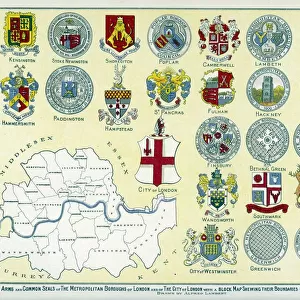
Map, Surrey Docks, Bricklayers Arms and New Cross, London

![]()
Wall Art and Photo Gifts from Mary Evans Picture Library
Map, Surrey Docks, Bricklayers Arms and New Cross, London
Map, Surrey Commercial Docks, Bricklayers Arms and New Cross, SE London, with railway lines and junctions.
1908
Mary Evans Picture Library makes available wonderful images created for people to enjoy over the centuries
Media ID 23106454
© Mary Evans / Pharcide
Bermondsey Bricklayers Canal Commercial Deptford Dock Docks Export Greenwich Inset Junction Junctions Lines Links Maps Midhurst Rotherhithe Surrey Tunnel Walk Wapping Wharf Willow
FEATURES IN THESE COLLECTIONS
> Architecture
> Tunnels
> Arts
> Landscape paintings
> Waterfall and river artworks
> River artworks
> Europe
> United Kingdom
> England
> London
> Boroughs
> Greenwich
> Europe
> United Kingdom
> England
> London
> Related Images
> Europe
> United Kingdom
> England
> London
> River Thames
> Europe
> United Kingdom
> England
> London
> Sights
> New River
> Europe
> United Kingdom
> England
> London
> Towns
> Bermondsey
> Europe
> United Kingdom
> England
> London
> Towns
> Deptford
> Europe
> United Kingdom
> England
> London
> Towns
> Greenwich
> Europe
> United Kingdom
> England
> London
> Towns
> New Cross
> Mary Evans Prints Online
> New Images August 2021
EDITORS COMMENTS
This photograph, taken in 1908, offers a glimpse into the bustling heart of South East London's industrial past. The Map and Surrey Docks, as seen in this image, played a pivotal role in the region's economic development during the Edwardian era. The docks, with their extensive network of wharves and quays, were a hub for the import and export of goods, primarily raw materials and finished products. The photograph showcases the intricate web of railway lines and junctions that linked the docks to various parts of the city and beyond. The Thames River, a vital artery for transportation, is also visible, with numerous ships anchored at the docks, waiting to be unloaded or loaded with cargo. The Bricklayers Arms and New Cross areas, located in the foreground, were bustling residential and commercial districts. The railway lines and junctions served as essential transportation links, making these areas easily accessible to the rest of the city. The photograph also reveals the presence of a tunnel and a bridge, likely part of the railway infrastructure, which allowed for seamless transportation between various parts of the city. The Willow Walk, a popular promenade in Rotherhithe, can be seen in the distance, adding to the vibrant and diverse character of the area. The inset map, located at the bottom right corner of the photograph, provides a clear overview of the surrounding areas, including Bermondsey, Greenwich, Deptford, Wapping, Rotherhithe, and Surrey. This map further highlights the extensive transportation network that connected these areas, making them integral to London's industrial and commercial growth during this period. Overall, this photograph offers a fascinating glimpse into the past, showcasing the intricate web of transportation links that connected London's industrial heart to the rest of the city and beyond.
MADE IN THE USA
Safe Shipping with 30 Day Money Back Guarantee
FREE PERSONALISATION*
We are proud to offer a range of customisation features including Personalised Captions, Color Filters and Picture Zoom Tools
SECURE PAYMENTS
We happily accept a wide range of payment options so you can pay for the things you need in the way that is most convenient for you
* Options may vary by product and licensing agreement. Zoomed Pictures can be adjusted in the Cart.