Home > Europe > Luxembourg > Maps
Map of Germany, Belgium, France illustrating Armistice

![]()
Wall Art and Photo Gifts from Mary Evans Picture Library
Map of Germany, Belgium, France illustrating Armistice
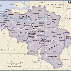
A map illustrating the Armistice at the end of World War One. The black line shows the battle line on Armistice Day, 11th November 1918. Belgium, France, Luxembourg and Alsace-Lorraine are to be evacuated by Germany. The left (west) bank of the Rhine is to be evacuated and will be under control of the Allied and United States Armies of Occupation. A neutral zone on the right (east) bank of the Rhine is to be set up. Date: November 1918
Mary Evans Picture Library makes available wonderful images created for people to enjoy over the centuries
Media ID 14128252
© Illustrated London News Ltd/Mary Evans
11th Alsace Armies Armistice Countries Illustrating Lorraine Luxembourg Maps Neutral Occupation Rhine Rhineland Zone
FEATURES IN THESE COLLECTIONS
> Europe
> Belgium
> Related Images
> Europe
> Luxembourg
> Maps
> Europe
> Luxembourg
> Posters
> Europe
> Luxembourg
> Related Images
> Europe
> Related Images
> Historic
> Battles
> Related Images
EDITORS COMMENTS
This evocative map print captures the momentous events of the Armistice at the end of World War One, signed on November 11, 1918. The black line demarcates the battle line on that fateful day, with Germany agreeing to evacuate Belgium, France, Luxembourg, and Alsace-Lorraine. The left (western) bank of the Rhine was to be evacuated and placed under the control of the Allied and United States Armies of Occupation. A neutral zone was established on the right (eastern) bank of the Rhine. This map serves as a powerful reminder of the significant territorial shifts that occurred following the end of the war. The Rhineland, which had been a source of tension and conflict between Germany and its neighbors for centuries, was now under Allied control. The map also highlights the impact of the war on countries such as Belgium and Luxembourg, which had been invaded and occupied by German forces. This historical map, with its intricate details and clear illustration of the Armistice terms, is an essential resource for students, historians, and anyone interested in the history of Europe during the First World War.
MADE IN THE USA
Safe Shipping with 30 Day Money Back Guarantee
FREE PERSONALISATION*
We are proud to offer a range of customisation features including Personalised Captions, Color Filters and Picture Zoom Tools
SECURE PAYMENTS
We happily accept a wide range of payment options so you can pay for the things you need in the way that is most convenient for you
* Options may vary by product and licensing agreement. Zoomed Pictures can be adjusted in the Cart.