Home > Europe > United Kingdom > England > Surrey > South Park
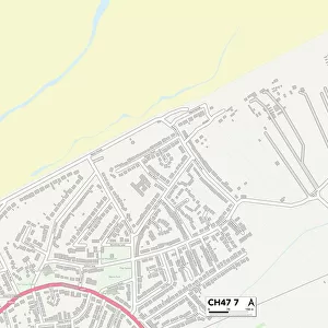
Wirral CH49 6 Map

![]()
Wall Art and Photo Gifts from Map Marketing
Wirral CH49 6 Map
Postcode Sector Map of Wirral CH49 6
Media ID 19967596
Benson Close Brookway Ch49 Church Road Dorchester Close Heath Drive Kirkway Longridge Avenue Manor Drive Meadway Melton Close Mount Road Newton Way Nuffield Close Oakland Drive Pendle Close Poplar Avenue South Drive Surrey Avenue The Limes The Paddock The Stables The Warren Tunstall Close Upland Road Upton Upton Close Wallingford Road West Drive Wirral Wychwood
FEATURES IN THESE COLLECTIONS
> Animals
> Mammals
> Muridae
> Heath Mouse
> Europe
> United Kingdom
> England
> Surrey
> Related Images
> Europe
> United Kingdom
> England
> Surrey
> South Park
> Map Marketing
> Postcode Sector Maps
> CH - Chester
> Maps and Charts
> Related Images
MADE IN THE USA
Safe Shipping with 30 Day Money Back Guarantee
FREE PERSONALISATION*
We are proud to offer a range of customisation features including Personalised Captions, Color Filters and Picture Zoom Tools
SECURE PAYMENTS
We happily accept a wide range of payment options so you can pay for the things you need in the way that is most convenient for you
* Options may vary by product and licensing agreement. Zoomed Pictures can be adjusted in the Cart.