Home > Arts > Street art graffiti > Digital art > Vector illustrations
Mountain View California US City Street Map

![]()
Wall Art and Photo Gifts from Fine Art Storehouse
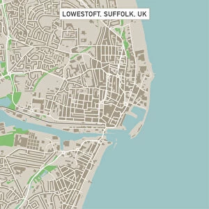
Mountain View California US City Street Map
Vector Illustration of a City Street Map of Mountain View, California, USA. Scale 1:60, 000.
All source data is in the public domain.
U.S. Geological Survey, US Topo
Used Layers:
USGS The National Map: National Hydrography Dataset (NHD)
USGS The National Map: National Transportation Dataset (NTD)
Unleash your creativity and transform your space into a visual masterpiece!
Frank Ramspott
Media ID 15055131
© Frank Ramspott, all rights reserved
Aerial View California City Map Computer Graphic Directly Above Downtown District Gray Road Map Text Digitally Generated Image Green Color Mountain View White Color
FEATURES IN THESE COLLECTIONS
> Aerial Photography
> Related Images
> Animals
> Insects
> Hemiptera
> Green Scale
> Animals
> Mammals
> Cricetidae
> California Mouse
> Arts
> Contemporary art
> Digital artwork
> Street art
> Arts
> Landscape paintings
> Waterfall and river artworks
> River artworks
> Arts
> Portraits
> Pop art gallery
> Street art portraits
> Arts
> Street art graffiti
> Digital art
> Digital paintings
> Arts
> Street art graffiti
> Digital art
> Vector illustrations
> Fine Art Storehouse
> Map
> Street Maps
> Fine Art Storehouse
> Map
> USA Maps
> Maps and Charts
> Geological Map
> Maps and Charts
> Related Images
EDITORS COMMENTS
This print showcases a detailed and intricate city street map of Mountain View, California, USA. The vector illustration beautifully captures the essence of this vibrant city, with its downtown district, river, lake, and bustling streets. With a scale of 1:60,000, every nook and cranny is meticulously depicted. The source data used for this artwork is in the public domain and comes from reputable sources such as the U. S. Geological Survey (USGS) - The National Map: National Hydrography Dataset (NHD) and National Transportation Dataset (NTD). These layers ensure accuracy in representing the hydrography features and transportation networks within Mountain View. Rendered using digital technology by talented artist Frank Ramspott, this visually stunning image offers an aerial view directly above the city. The color palette includes shades of gray for roads and text labels while incorporating green for parks or natural areas, blue for water bodies like rivers or lakes, and white to highlight buildings. Perfectly suited for cartography enthusiasts or anyone fascinated by urban landscapes, this print brings together design aesthetics with precise mapping techniques. It's an ideal addition to any art collection that appreciates digitally generated images capturing physical geography without people present.
MADE IN THE USA
Safe Shipping with 30 Day Money Back Guarantee
FREE PERSONALISATION*
We are proud to offer a range of customisation features including Personalised Captions, Color Filters and Picture Zoom Tools
SECURE PAYMENTS
We happily accept a wide range of payment options so you can pay for the things you need in the way that is most convenient for you
* Options may vary by product and licensing agreement. Zoomed Pictures can be adjusted in the Cart.