Home > Aerial Photography > Related Images
Henderson Nevada US City Street Map

![]()
Wall Art and Photo Gifts from Fine Art Storehouse
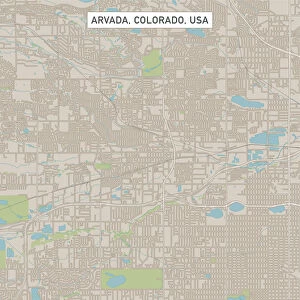
Henderson Nevada US City Street Map
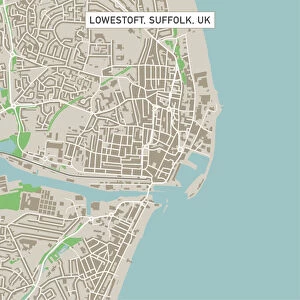
Vector Illustration of a City Street Map of Henderson, Nevada, USA. Scale 1:60, 000.
All source data is in the public domain.
U.S. Geological Survey, US Topo
Used Layers:
USGS The National Map: National Hydrography Dataset (NHD)
USGS The National Map: National Transportation Dataset (NTD)
Unleash your creativity and transform your space into a visual masterpiece!
Frank Ramspott
Media ID 15055021
© Frank Ramspott, all rights reserved
Aerial View City Map Computer Graphic Directly Above Downtown District Gray Nevada Road Map Text Digitally Generated Image Henderson White Color
FEATURES IN THESE COLLECTIONS
> Aerial Photography
> Related Images
> Arts
> Contemporary art
> Digital artwork
> Street art
> Arts
> Landscape paintings
> Waterfall and river artworks
> River artworks
> Arts
> Portraits
> Pop art gallery
> Street art portraits
> Arts
> Street art graffiti
> Digital art
> Digital paintings
> Arts
> Street art graffiti
> Digital art
> Vector illustrations
> Fine Art Storehouse
> Map
> Street Maps
> Fine Art Storehouse
> Map
> USA Maps
> Maps and Charts
> Geological Map
> Maps and Charts
> Related Images
> North America
> United States of America
> Lakes
> Related Images
> North America
> United States of America
> Maps
EDITORS COMMENTS
This print showcases a meticulously detailed city street map of Henderson, Nevada, USA. The vector illustration captures the essence of this vibrant city with its downtown district, serene lake, and meandering river. With a scale of 1:60,000, every intricate detail is brought to life in this digitally generated image. The source data used for this masterpiece is all in the public domain and comes from reputable sources such as the U. S. Geological Survey (USGS) and their National Hydrography Dataset (NHD) as well as the National Transportation Dataset (NTD). These layers provide accurate information on roads and hydrographic features. In this visually stunning aerial view captured directly above Henderson, we can appreciate the artistry behind cartography and map design. The color palette chosen by Frank Ramspott includes shades of gray, blue, and white that beautifully complement each other. What makes this print truly remarkable is its ability to transport us into an imaginary world where we can explore every nook and cranny of Henderson without ever leaving our homes. It's a testament to human ingenuity that such intricate maps can be created using computer graphics. This print serves as both a work of art and a practical tool for navigation enthusiasts or those who simply appreciate the beauty found in physical geography. Its absence of people allows us to focus solely on the mesmerizing details presented before us.
MADE IN THE USA
Safe Shipping with 30 Day Money Back Guarantee
FREE PERSONALISATION*
We are proud to offer a range of customisation features including Personalised Captions, Color Filters and Picture Zoom Tools
SECURE PAYMENTS
We happily accept a wide range of payment options so you can pay for the things you need in the way that is most convenient for you
* Options may vary by product and licensing agreement. Zoomed Pictures can be adjusted in the Cart.