Home > Granger Art on Demand > Miscellaneous
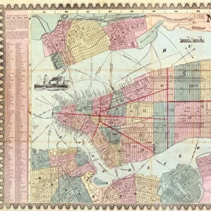
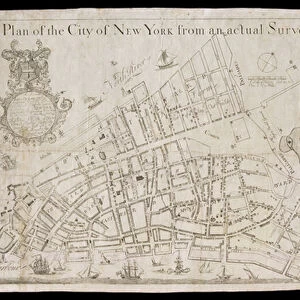
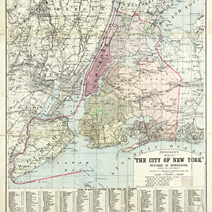
MAP: QUEENS, 1923. A map of the borough of Queens and its surroundings

![]()
Wall Art and Photo Gifts from Granger
MAP: QUEENS, 1923. A map of the borough of Queens and its surroundings
MAP: QUEENS, 1923.
A map of the borough of Queens and its surroundings. Map by Williams Map & Guide Co. 1923
Granger holds millions of images spanning more than 25,000 years of world history, from before the Stone Age to the dawn of the Space Age
Media ID 13136209
1923 Borough District New York New York City Queens
EDITORS COMMENTS
This print titled "MAP: QUEENS, 1923" takes us back in time to explore the borough of Queens and its surroundings. The map, created by Williams Map & Guide Co. in 1923, offers a fascinating glimpse into the layout and streets of this vibrant district within New York City. As we delve into the details of this vintage map, we are transported to an era where horse-drawn carriages traversed these streets and bustling neighborhoods were just beginning to take shape. The intricate network of roads crisscrossing through Queens tells a story of urban development and growth that has transformed this area over the years. The Granger Collection's artful presentation allows us to appreciate not only the historical significance but also the artistic beauty embedded within this piece. Every street corner is meticulously illustrated with precision and care, showcasing a level of craftsmanship that was characteristic of cartographers during that time. Whether you have personal ties to Queens or simply have an appreciation for history, this print serves as a window into New York City's past. It invites us to imagine what life was like nearly a century ago while simultaneously reminding us how much our cities have evolved since then. With its rich historical context and visual appeal, "MAP: QUEENS, 1923" from Granger Art on Demand is sure to captivate anyone with an interest in maps or those who seek unique decor pieces that tell stories from another era.
MADE IN THE USA
Safe Shipping with 30 Day Money Back Guarantee
FREE PERSONALISATION*
We are proud to offer a range of customisation features including Personalised Captions, Color Filters and Picture Zoom Tools
SECURE PAYMENTS
We happily accept a wide range of payment options so you can pay for the things you need in the way that is most convenient for you
* Options may vary by product and licensing agreement. Zoomed Pictures can be adjusted in the Cart.