Home > North America > Mexico > Mexico City
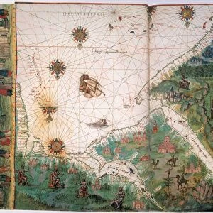
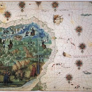
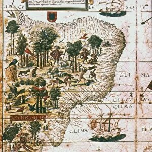
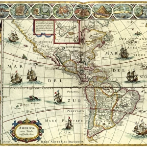
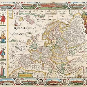
NEW WORLD MAP, 1547. Map of the West Indies and Central American from the Vallard Atlas

![]()
Wall Art and Photo Gifts from Granger
NEW WORLD MAP, 1547. Map of the West Indies and Central American from the Vallard Atlas
NEW WORLD MAP, 1547. Map of the West Indies and Central American from the Vallard Atlas, c. 1547; the map, drawn " upside-down" as if viewed from Europe, shows Mexico City in the north and mining in northern South America
Granger holds millions of images spanning more than 25,000 years of world history, from before the Stone Age to the dawn of the Space Age
Media ID 6622385
1547 Age Of Discovery Caribbean Central Island Latin America Mesoamerica Mexico New World Portolan Chart Topography
FEATURES IN THESE COLLECTIONS
> Europe
> Related Images
> Granger Art on Demand
> Maps
> Maps and Charts
> World
> North America
> Mexico
> Mexico City
> South America
> Related Images
EDITORS COMMENTS
This print showcases a remarkable piece of history - the "NEW WORLD MAP, 1547". Taken from the Vallard Atlas, this map provides a unique perspective on the West Indies and Central America during the Renaissance era. What sets it apart is that it is drawn "upside-down" as if viewed from Europe. As we delve into this extraordinary artwork, our eyes are immediately drawn to Mexico City in the north. This bustling metropolis stands out amidst a sea of intricate details and vibrant colors. The map also highlights mining activities in northern South America, giving us a glimpse into the economic significance of these regions during that time. The topography depicted on this map offers an intriguing insight into how early cartographers perceived Latin America and its surrounding islands. It serves as a testament to their knowledge of geography during the Age of Discovery when explorers were venturing into uncharted territories. Through this image, we can appreciate not only the technical skill involved in creating such intricate maps but also gain an understanding of how Europeans visualized and understood distant lands centuries ago. It reminds us of their curiosity about new frontiers and their desire to document these discoveries for future generations. This Granger Collection print transports us back in time, allowing us to marvel at an important artifact from our collective past – a fascinating window into the New World's exploration and cultural exchange during one of history's most transformative periods.
MADE IN THE USA
Safe Shipping with 30 Day Money Back Guarantee
FREE PERSONALISATION*
We are proud to offer a range of customisation features including Personalised Captions, Color Filters and Picture Zoom Tools
SECURE PAYMENTS
We happily accept a wide range of payment options so you can pay for the things you need in the way that is most convenient for you
* Options may vary by product and licensing agreement. Zoomed Pictures can be adjusted in the Cart.