Home > Arts > Landscape paintings > Waterfall and river artworks > River artworks
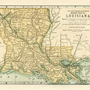
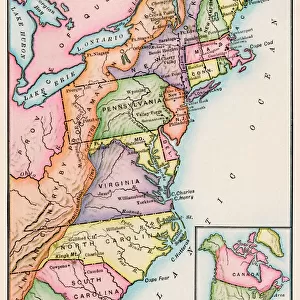
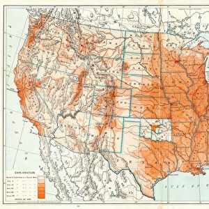
MAP: UNITED STATES, 1820. Engraved map of the United States, 1820, drawing on the geographical discoveries of the Lewis

![]()
Wall Art and Photo Gifts from Granger
MAP: UNITED STATES, 1820. Engraved map of the United States, 1820, drawing on the geographical discoveries of the Lewis
MAP: UNITED STATES, 1820. Engraved map of the United States, 1820, drawing on the geographical discoveries of the Lewis & Clark expedition
Granger holds millions of images spanning more than 25,000 years of world history, from before the Stone Age to the dawn of the Space Age
Media ID 6617689
1820 Louisiana Purchase Territory Westward Expansion
FEATURES IN THESE COLLECTIONS
> Arts
> Landscape paintings
> Waterfall and river artworks
> River artworks
> Granger Art on Demand
> Maps
> Maps and Charts
> Early Maps
EDITORS COMMENTS
This print showcases an engraved map of the United States from the year 1820, meticulously drawing on the geographical discoveries made during the renowned Lewis & Clark expedition. The map beautifully captures a pivotal moment in American history, as it reflects both the late stages of westward expansion and the early development of this great nation. The intricate details depicted on this map highlight various territories and rivers that played significant roles in shaping America's destiny. It serves as a visual testament to the vastness and diversity of this young country at that time. One cannot help but be mesmerized by its artistry, which expertly combines accuracy with artistic flair. Of particular note is how this map represents one of America's most monumental acquisitions – the Louisiana Purchase. This historic event doubled the size of our nation overnight and opened up new opportunities for exploration, settlement, and trade. As we gaze upon this remarkable piece from The Granger Collection, we are transported back to a time when America was still forging its identity amidst untamed wildernesses and uncharted territories. It reminds us not only of our rich history but also inspires us to appreciate those who fearlessly ventured into unknown lands to shape our present reality. Whether you are an avid historian or simply captivated by artistry, this print is sure to ignite your imagination and spark conversations about America's past achievements while serving as a reminder that there is always more to discover within ourselves and beyond our borders.
MADE IN THE USA
Safe Shipping with 30 Day Money Back Guarantee
FREE PERSONALISATION*
We are proud to offer a range of customisation features including Personalised Captions, Color Filters and Picture Zoom Tools
SECURE PAYMENTS
We happily accept a wide range of payment options so you can pay for the things you need in the way that is most convenient for you
* Options may vary by product and licensing agreement. Zoomed Pictures can be adjusted in the Cart.