Home > Maps and Charts > World
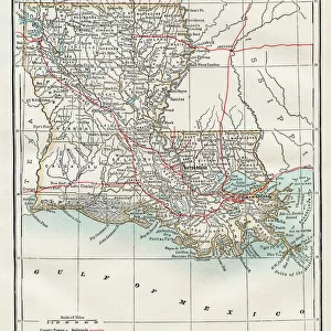
Louisiana map 1898

![]()
Wall Art and Photo Gifts from Fine Art Storehouse
Louisiana map 1898
Map from the Complete Handy Atlas of the World - 1898
Unleash your creativity and transform your space into a visual masterpiece!
THEPALMER
Media ID 20249935
© A 2014 Roberto Adrian Photography
FEATURES IN THESE COLLECTIONS
> Fine Art Storehouse
> Map
> Historical Maps
> Maps and Charts
> Early Maps
> Maps and Charts
> World
EDITORS COMMENTS
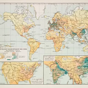
In this print titled "Louisiana map 1898" we are transported back in time to the late 19th century. The image showcases a meticulously detailed map from the Complete Handy Atlas of the World, published in 1898. Created by THEPALMER, this piece offers a glimpse into an era when cartography was both an art form and a scientific endeavor. The Louisiana map takes center stage, displaying intricate topographical features and geographical boundaries that define the state's unique landscape. From its meandering rivers to its sprawling marshlands, every detail is delicately rendered with precision and care. This vintage representation allows us to appreciate how much has changed over the years while also highlighting the enduring beauty of Louisiana's natural surroundings. As we explore this historical artifact, it becomes evident that maps serve as more than just navigational tools; they tell stories of exploration, settlement, and cultural identity. Through THEPALMER's expertly crafted photograph, we can almost feel ourselves stepping into the past—a time when these maps were essential for understanding our world. Whether you have a personal connection to Louisiana or simply admire antique cartography, this print serves as a reminder of our ever-evolving relationship with geography. It invites us to reflect on how far we've come since 1898 while cherishing the rich history embedded within each contour line and place name on this remarkable map.
MADE IN THE USA
Safe Shipping with 30 Day Money Back Guarantee
FREE PERSONALISATION*
We are proud to offer a range of customisation features including Personalised Captions, Color Filters and Picture Zoom Tools
SECURE PAYMENTS
We happily accept a wide range of payment options so you can pay for the things you need in the way that is most convenient for you
* Options may vary by product and licensing agreement. Zoomed Pictures can be adjusted in the Cart.