Home > Granger Art on Demand > American Revolution
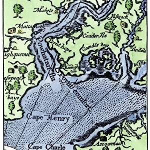
Map of the siege of Yorktown, compiled from the Faden (London, 1781) and the Renault (American, 1781) maps by Lieut. L. V. Caziarc, 1881
 and the Renault (American, 1781) maps by Lieut. L. V. Caziarc, 1881")
![]()
Wall Art and Photo Gifts from Granger
Map of the siege of Yorktown, compiled from the Faden (London, 1781) and the Renault (American, 1781) maps by Lieut. L. V. Caziarc, 1881
BATTLE OF YORKTOWN, 1781.
Map of the siege of Yorktown, compiled from the Faden (London, 1781) and the Renault (American, 1781) maps by Lieut. L.V. Caziarc, 1881
Granger holds millions of images spanning more than 25,000 years of world history, from before the Stone Age to the dawn of the Space Age
Media ID 7964149
1781 American Revolution Document Rebellion Siege Of Yorktown South East United States Yorktown Faden Renault
EDITORS COMMENTS
This print showcases a historical treasure, the "Map of the siege of Yorktown" meticulously compiled by Lieutenant L. V. Caziarc in 1881. This remarkable document is a fusion of two significant maps from 1781: the Faden map from London and the Renault map from America. The Battle of Yorktown, which took place during the American Revolution in 1781, marked a turning point in history as it led to British surrender and ultimately paved the way for American independence. This map vividly illustrates the strategic layout of Yorktown, situated in South East United States. Lieutenant Caziarc's dedication to preserving this crucial piece of history is evident through his careful compilation and attention to detail. The merging of these two original maps provides an invaluable resource for historians and enthusiasts alike, offering insights into troop movements, fortifications, and geographical features that played pivotal roles during this historic battle. As we explore this image further, we are transported back in time to witness how rivers shaped military strategies while towns like Yorktown became focal points for rebellion against British rule. It serves as a reminder not only of our nation's struggle for freedom but also highlights the importance of cartography as an essential tool for understanding past events. Granger Art on Demand has once again provided us with a visual gem that encapsulates both artistry and historical significance within its frame—a true testament to their commitment to sharing knowledge through stunning imagery.
MADE IN THE USA
Safe Shipping with 30 Day Money Back Guarantee
FREE PERSONALISATION*
We are proud to offer a range of customisation features including Personalised Captions, Color Filters and Picture Zoom Tools
FREE COLORIZATION SERVICE
You can choose advanced AI Colorization for this picture at no extra charge!
SECURE PAYMENTS
We happily accept a wide range of payment options so you can pay for the things you need in the way that is most convenient for you
* Options may vary by product and licensing agreement. Zoomed Pictures can be adjusted in the Cart.