Home > North America > Canada > Maps
EXPL2A-00038

![]()
Wall Art and Photo Gifts from North Wind
EXPL2A-00038
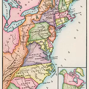
Map of the U.S. boundary disputes with Spain and Great Britain, 1810-1812.
Printed color lithograph of a 19th-century illustration
North Wind Picture Archives brings history to life with stock images and hand-colored illustrations
Media ID 5877460
© North Wind Picture Archives
1812 Border Boundary British Canada Canadian Louisiana Territory Mexico New Spain Oregon Oregon Territory Spanish States Territory Texas War Of 1812 1810 British Territory
FEATURES IN THESE COLLECTIONS
> Europe
> Spain
> Related Images
> Maps and Charts
> Related Images
> Maps and Charts
> Spain
> North America
> Canada
> Maps
> North America
> Canada
> Related Images
> North America
> Mexico
> Related Images
> North America
> Related Images
> North Wind Picture Archives
> American history
> North Wind Picture Archives
> Maps
EDITORS COMMENTS
This vintage print showcases the intricate and tumultuous history of boundary disputes between the United States, Spain, and Great Britain during the early 19th century. Titled "Map of the U. S. Boundary Disputes with Spain and Great Britain, 1810-1812" this printed color lithograph offers a fascinating glimpse into North America's territorial complexities. The map depicts various regions such as Texas, Oregon Territory, British territory (Canada), Spanish territory (New Spain), Louisiana Territory, and more. It highlights the contested borders that were subject to heated negotiations and occasional conflicts during this period. With meticulous detail and artistic flair, this illustration captures an important era in American history when nations vied for control over vast expanses of land. The boundaries depicted on this map reflect not only political ambitions but also cultural identities that shaped North America's future. As we delve into this historical artifact, we are reminded of significant events like the War of 1812 which further influenced these border disputes. This print serves as a visual testament to the complex relationships between nations striving for dominance in a rapidly changing continent. Whether you are an enthusiast of cartography or simply intrigued by tales from yesteryears, this artwork transports us back to a time when borders were fluid and territories fiercely contested.
MADE IN THE USA
Safe Shipping with 30 Day Money Back Guarantee
FREE PERSONALISATION*
We are proud to offer a range of customisation features including Personalised Captions, Color Filters and Picture Zoom Tools
SECURE PAYMENTS
We happily accept a wide range of payment options so you can pay for the things you need in the way that is most convenient for you
* Options may vary by product and licensing agreement. Zoomed Pictures can be adjusted in the Cart.