Home > Europe > United Kingdom > England > London > Museums > London Canal Museum
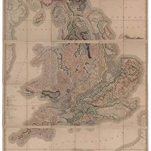
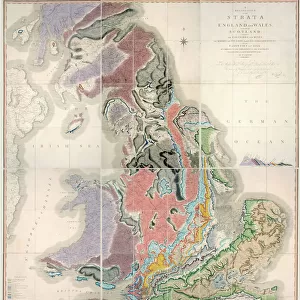
First geological map of Britain, 1815 C016 / 5682

![]()
Wall Art and Photo Gifts from Science Photo Library
First geological map of Britain, 1815 C016 / 5682
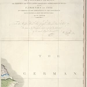
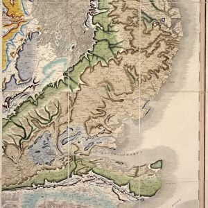
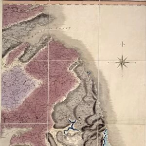
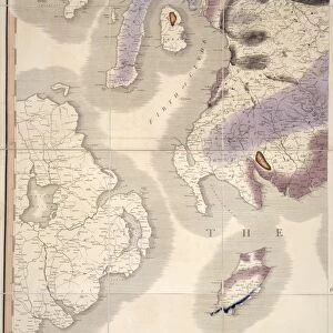
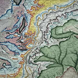
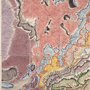
First geological map of Britain, detail of the Welsh coast (figure 7). This map was published in 1815 by British geologist William Smith (1769-1839). It shows rock layers (strata) in England and Wales and part of Scotland (key at lower left). Smiths work as a canal surveyor allowed him to study geology. He discovered that geological strata could be reliably identified at different places on the basis of the fossils they contained. Smith also proposed the principle of superposition, that if a strata overlays another then it was laid down at a later time. He is considered the father of English geology
Science Photo Library features Science and Medical images including photos and illustrations
Media ID 9206563
© NATURAL HISTORY MUSEUM, LONDON/SCIENCE PHOTO LIBRARY
1815 Cartography Country Earth Science Geological Great Britain Pioneering Region Scottish Strata Stratigraphy Stratum Superposition Wales Welsh William Smith
FEATURES IN THESE COLLECTIONS
> Europe
> Related Images
> Europe
> United Kingdom
> England
> London
> Museums
> British Library
> Europe
> United Kingdom
> England
> London
> Museums
> British Museum
> Europe
> United Kingdom
> England
> London
> Museums
> London Canal Museum
> Europe
> United Kingdom
> England
> London
> Museums
> Natural History Museum
> Europe
> United Kingdom
> England
> London
> Museums
> Science Museum
> Europe
> United Kingdom
> England
> London
> Sights
> British Museum
> Europe
> United Kingdom
> England
> London
> Sights
> London Canal Museum
> Europe
> United Kingdom
> England
> London
> Towns
> Lower Place
> Europe
> United Kingdom
> England
> Maps
EDITORS COMMENTS
This print showcases the first geological map of Britain, a groundbreaking work published in 1815 by British geologist William Smith. The intricate detail captured in this image focuses on the Welsh coast (figure 7), revealing the fascinating rock layers (strata) that make up England and Wales, as well as part of Scotland. William Smith's remarkable contribution to geology stemmed from his profession as a canal surveyor, which provided him with ample opportunities to study the Earth's composition. Through meticulous observation, he made a revolutionary discovery – different geological strata could be reliably identified based on the fossils they contained. Smith's pioneering work also introduced the principle of superposition: if one layer of rock overlays another, it was deposited at a later time. This concept revolutionized our understanding of Earth's history and earned him recognition as the father of English geology. The accompanying key at the lower left corner offers valuable insights into specific regions depicted on this historic map. As an artwork born out of scientific inquiry and cartography, this illustration represents an invaluable piece of European history from the early 19th century. Preserved by NATURAL HISTORY MUSEUM, LONDON/SCIENCE PHOTO LIBRARY, this print serves as a testament to William Smith's immense contributions to earth science and stratigraphy. It stands not only as an important historical artifact but also as a reminder of how human curiosity can unlock profound knowledge about our planet's past.
MADE IN THE USA
Safe Shipping with 30 Day Money Back Guarantee
FREE PERSONALISATION*
We are proud to offer a range of customisation features including Personalised Captions, Color Filters and Picture Zoom Tools
SECURE PAYMENTS
We happily accept a wide range of payment options so you can pay for the things you need in the way that is most convenient for you
* Options may vary by product and licensing agreement. Zoomed Pictures can be adjusted in the Cart.