Home > Maps and Charts > Americas
Map of Vicksburg

![]()
Wall Art and Photo Gifts from Mary Evans Picture Library
Map of Vicksburg
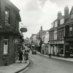
Map of Vicksburg, Mississippi, during the US Civil War when Ulyssess Grant and his army of the Tennessee drove the Confederate army of John C Pemberton back to Vicksburg and besieged the city. A small map of Port Hudson and Baton-Rouge is also included
Mary Evans Picture Library makes available wonderful images created for people to enjoy over the centuries
Media ID 4479409
© Mary Evans Picture Library 2015 - https://copyrighthub.org/s0/hub1/creation/maryevans/MaryEvansPictureID/10470821
1863 Baton Hudson Maps Mississippi Rouge Siege Vicksburg
FEATURES IN THESE COLLECTIONS
> Maps and Charts
> Early Maps
> Maps and Charts
> Related Images
EDITORS COMMENTS
This antique map print offers a fascinating glimpse into the pivotal moment of the American Civil War when Union forces under the command of General Ulysses S. Grant laid siege to the Confederate stronghold of Vicksburg, Mississippi, in 1863. The strategic location of Vicksburg, situated on high ground overlooking the Mississippi River, made it a crucial objective for the Union to secure control of the waterway and split the Confederacy in two. The intricately detailed map illustrates the city of Vicksburg and its surrounding areas, including the nearby towns of Port Hudson and Baton Rouge in Louisiana. The map's border is adorned with vignettes depicting various scenes from the siege, such as Union soldiers constructing fortifications and Confederate soldiers surrendering. The map provides an excellent visual representation of the military maneuvers that took place during this significant period in American history. Grant's forces, having driven the Confederate army of John C. Pemberton back to Vicksburg, began the siege on May 18, 1863, and after a grueling 47-day campaign, the Confederates surrendered on July 4, 1863. With the fall of Vicksburg, the Union gained control of the Mississippi River and dealt a major blow to the Confederacy. This historical map print is an essential addition to any collection focusing on the American Civil War or the history of Mississippi. Its intricate details and captivating vignettes make it a beautiful and informative piece for display in a home, office, or educational institution.
MADE IN THE USA
Safe Shipping with 30 Day Money Back Guarantee
FREE PERSONALISATION*
We are proud to offer a range of customisation features including Personalised Captions, Color Filters and Picture Zoom Tools
SECURE PAYMENTS
We happily accept a wide range of payment options so you can pay for the things you need in the way that is most convenient for you
* Options may vary by product and licensing agreement. Zoomed Pictures can be adjusted in the Cart.