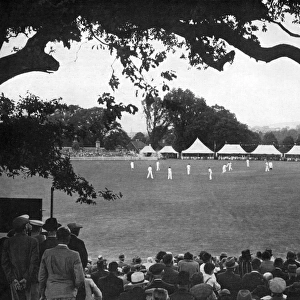
Home > Europe > United Kingdom > England > London > Towns > Welling
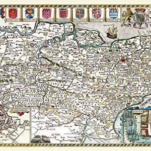
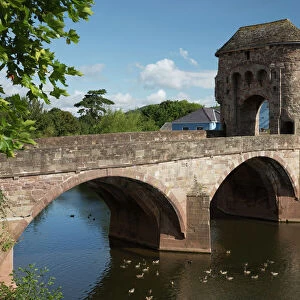
Old County Map of Monmouthshire 1836 by Thomas Moule

![]()
Wall Art and Photo Gifts from MapSeeker
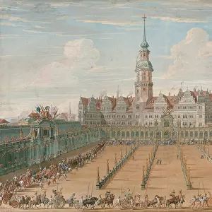
Old County Map of Monmouthshire 1836 by Thomas Moule
This is a fine decorative reproduction County Map of Monmouthshire from the First Edition series of Thomas Moule Maps, originally Published in 1836. The well-known series of County Maps which are known as Moules feature beautiful vignette views and were first published in separate sections for each county in 1830-32, they were then published in collected form in a two-volume work: The English Counties Delineated: or a Topographical Description of England: Illustrated by a Complete Series of County Maps by Thomas Moule: London: Published by George Virtue 1836
Welcome to the Mapseeker Image library and enter an historic gateway to one of the largest on-line collections of Historic Maps, Nostalgic Views, Vista's and Panorama's from a World gone by.
Media ID 20347925
© Mapseeker Publishing Ltd
County Map County Map Of England English County Map Historic Map Moule Map Old County Map Old English County Map Old Moule Map Thomas Moule Thomas Moule Map Monmouthshire
FEATURES IN THESE COLLECTIONS
> Arts
> Artists
> M
> Thomas Moule
> Europe
> United Kingdom
> England
> London
> Towns
> Welling
> Europe
> United Kingdom
> England
> Maps
> Europe
> United Kingdom
> England
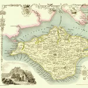
> Wells
> Europe
> United Kingdom
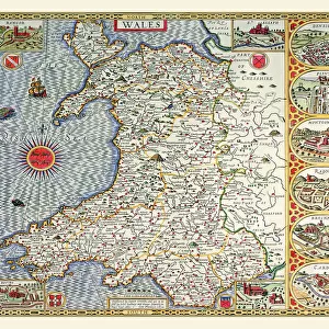
> Wales
> Monmouthshire
> Related Images
> Maps and Charts
> Early Maps
> Maps and Charts
> Related Images
> MapSeeker
> Maps from the British Isles
> England and Counties PORTFOLIO
> MapSeeker
> Maps from the British Isles
> Wales and Counties PORTFOLIO
EDITORS COMMENTS
This exquisite print showcases the "Old County Map of Monmouthshire 1836" by Thomas Moule, a renowned cartographer from the early 19th century. Originally published as part of Moule's First Edition series in 1836, this decorative reproduction captures the beauty and intricacy of his work. Moule's County Maps are highly regarded for their stunning vignette views and meticulous attention to detail. This particular map was first released in separate sections for each county between 1830 and 1832 before being compiled into a two-volume masterpiece titled "The English Counties Delineated: or a Topographical Description of England". Published by George Virtue in London, this comprehensive collection became an invaluable resource for those seeking to explore and understand the diverse landscapes of England. Monmouthshire, located in southeastern Wales, is brought to life through Moule's artistry. The historical significance of this map cannot be overstated; it offers a glimpse into the past with its depiction of towns, villages, rivers, roads, and landmarks that have shaped Monmouthshire over centuries. Whether you are an avid collector or simply appreciate historical cartography, this print allows you to admire Thomas Moule's mastery from the comfort of your own home. Let it transport you back to a time when maps were not only practical tools but also works of art that celebrated our connection to the land we inhabit.
MADE IN THE USA
Safe Shipping with 30 Day Money Back Guarantee
FREE PERSONALISATION*
We are proud to offer a range of customisation features including Personalised Captions, Color Filters and Picture Zoom Tools
SECURE PAYMENTS
We happily accept a wide range of payment options so you can pay for the things you need in the way that is most convenient for you
* Options may vary by product and licensing agreement. Zoomed Pictures can be adjusted in the Cart.


![N. E. R Bilton [Alnmouth] Station - Additional Details for Windows [1886]](/sq/229/n-e-r-bilton-alnmouth-station-additional-14743604.jpg.webp)