Fraud Blocker Skip to main content

Home > Europe > United Kingdom > England > London > Towns > Paddington
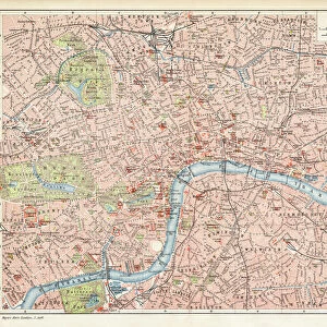
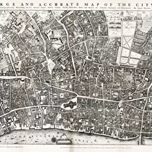
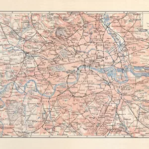
London Map 1806

London Map 1806


Canvas Prints
Fine Art Prints
Metal Prints
Home Decor


We accept all major credit cards

Mary Evans Prints Online

Wall Art and Photo Gifts from Mary Evans Picture Library

London Map 1806

London extending from the head of the Paddington Canal West, and to the West India Docks East. Date: 1806

Mary Evans Picture Library makes available wonderful images created for people to enjoy over the centuries

Media ID 14350896

© Mary Evans Picture Library

1806 Churches Maps Plan Squares


FEATURES IN THESE COLLECTIONS

> Arts > Landscape paintings > Waterfall and river artworks > River artworks

> Asia > India > Maps

> Asia > India > Related Images

> Europe > United Kingdom > England > London > Related Images

> Europe > United Kingdom > England > London > River Thames

> Europe > United Kingdom > England > London > Towns > Paddington

> Europe > United Kingdom > England > Maps

> Europe > United Kingdom > England > Posters

> Europe > United Kingdom > England > Related Images

> Europe > United Kingdom > England > Rivers


MADE IN THE USA
Safe Shipping with 30 Day Money Back Guarantee

FREE PERSONALISATION*
We are proud to offer a range of customisation features including Personalised Captions, Color Filters and Picture Zoom Tools

SECURE PAYMENTS
We happily accept a wide range of payment options so you can pay for the things you need in the way that is most convenient for you

* Options may vary by product and licensing agreement. Zoomed Pictures can be adjusted in the Cart.


redeem
Beautiful Photo Prints and Gifts
image
Professionally Printed
inventory
Photo Prints are in stock
thumb_up
Professional quality finish
diamond
Made with high-grade materials
inventory_2
Carefully packed to aid safe arrival


Related Images


London city map 1895
London Map 1756
London Map 1756
London city map
London city map
Antquie Map of London, 1895
Map of the City of London by John Ogilby 1676. Ogilby (also Ogelby
TOWER OF LONDON, 1560. Detail from the Agas map of 1560 showing the Tower of London on the Thames River
Lenin and Stalin sitting on a bench
Map of London 1900
Map of London 1900
City map of London with suburbs, England, lithograph, published 1897
England, London, St Katherines Dock
Covent Garden Market Christmas lights switched on, Covent Garden, London
Castle Combe, Cotswolds, Gloucestershire, England, UK

+

Shipping

+

Choices

+

Reviews

+

Guaranteed


Related Collections


India Related Images
Browse 41,202 Prints
England Related Images
Browse 46,732 Prints
Maps
Maps
Browse 661 Prints
London Related Images
Browse 47,003 Prints
River Thames
River Thames
Browse 8,797 Prints
Paddington
Paddington
Browse 465 Prints
Maps
Maps
Browse 9,933 Prints
Posters
Posters
Browse 44,542 Prints
Rivers
Rivers
Browse 11,741 Prints
River artworks
River artworks
Browse 41,055 Prints