Home > Animals > Mammals > Muridae > Heath Mouse
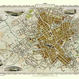
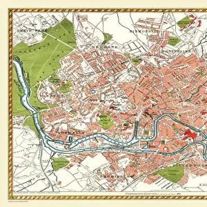
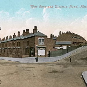
Old Map of Birmingham 1893 from the Comprehensive Gazetteer Atlas of England and Wales

![]()
Wall Art and Photo Gifts from MapSeeker
Old Map of Birmingham 1893 from the Comprehensive Gazetteer Atlas of England and Wales
This detailed reproduction plan of Birmingham has been re-worked from an antique originally published in the oComprehensive Gazetteer of England and Waleso 1893. All roads, railways and individual stations have been identified. The parks in and around Birmingham are now established, this map is most likely to be the first to show the Warwickshire Cricket Ground. The village of Harborne to the bottom left of the plan is yet to be drawn into the expanding conurbation. The plan includes Handsworth, Lozzells, Gibheath, Winston Green, Hockley, Brookfields, Saltley, Ladywood, Deritend, Bordsley, Highgate, Sparkbrook, Harborne, Edgebaston, and Balsall Heath
Welcome to the Mapseeker Image library and enter an historic gateway to one of the largest on-line collections of Historic Maps, Nostalgic Views, Vista's and Panorama's from a World gone by.
Media ID 20347432
Birmingham Birmingham City Birmingham City Map Birmingham Map Birmingham Town Plan City Of Birmingham Map Historic Birmingham Map Historic Map Map Of Birmingham Old Map Of Birmingham Old Town Plan Town Plan Of Birmingham William Mackenzie
FEATURES IN THESE COLLECTIONS
> Animals
> Mammals
> Muridae
> Heath Mouse
> Arts
> Artists
> H
> William Heath
> Arts
> Photorealistic artworks
> Detailed art pieces
> Masterful detailing in art
> Europe
> United Kingdom
> England
> Birmingham
> Area
> Balsall Heath
> Europe
> United Kingdom
> England
> Birmingham
> Area
> Deritend
> Europe
> United Kingdom
> England
> Birmingham
> Area
> Handsworth
> Europe
> United Kingdom
> England
> Birmingham
> Area
> Harborne
> Europe
> United Kingdom
> England
> Birmingham
> Area
> Highgate
> Europe
> United Kingdom
> England
> Birmingham
> Area
> Hockley
> Europe
> United Kingdom
> England
> Birmingham
> Area
> Ladywood
> MapSeeker
> British Town And City Plans
> English & Welsh PORTFOLIO
EDITORS COMMENTS
This beautifully detailed reproduction print showcases the "Old Map of Birmingham 1893" from the Comprehensive Gazetteer Atlas of England and Wales. A true treasure for history enthusiasts, this antique map offers a glimpse into the past, capturing Birmingham's evolving landscape at that time. Every road, railway line, and individual station has been meticulously identified on this map. It also highlights the establishment of parks in and around Birmingham, with special mention given to what is likely the first depiction of Warwickshire Cricket Ground. Interestingly, the village of Harborne remains separate from the expanding conurbation depicted on this plan. The towns and neighborhoods featured on this historic map include Handsworth, Lozzells, Gibheath, Winston Green, Hockley, Brookfields, Saltley, Ladywood, Deritend, Bordsley Highgate Sparkbrook Harborne Edgebaston Balsall Heath. These names evoke a sense of nostalgia as we imagine how these areas have transformed over time. With its intricate details and rich historical significance, this old town plan provides an invaluable resource for researchers or anyone curious about Birmingham's past. Whether you're exploring your roots or simply appreciating the city's heritage, this comprehensive gazetteer atlas reproduction will transport you back to a bygone era.
MADE IN THE USA
Safe Shipping with 30 Day Money Back Guarantee
FREE PERSONALISATION*
We are proud to offer a range of customisation features including Personalised Captions, Color Filters and Picture Zoom Tools
SECURE PAYMENTS
We happily accept a wide range of payment options so you can pay for the things you need in the way that is most convenient for you
* Options may vary by product and licensing agreement. Zoomed Pictures can be adjusted in the Cart.