Home > North America > The Bahamas > Maps
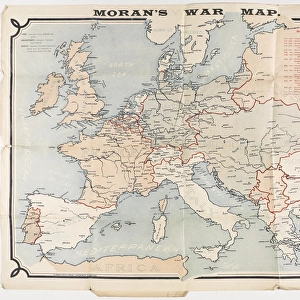
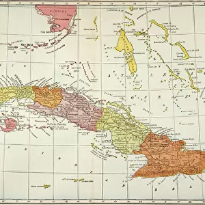
Antonio De Herrera Y Tordesillas Map Of The Bahamas, 1601. From The Book Life Of Christopher Columbus By Clements R. Markham Published 1892

![]()
Wall Art and Photo Gifts from Design Pics
Antonio De Herrera Y Tordesillas Map Of The Bahamas, 1601. From The Book Life Of Christopher Columbus By Clements R. Markham Published 1892
Design Pics offers Distinctively Different Imagery representing over 1,500 contributors
Media ID 18177184
© Hilary Jane Morgan / Design Pics
Antonio Bahamas Cartography Chart Christopher Colon Columbus Cristobal Cristoval Cuba Geographical Geography Mapmaking World 1601 Espanola Herrera Tordesillas
FEATURES IN THESE COLLECTIONS
> Design Pics
> Design Pics Art
> Art llustrations and Engravings
> Maps and Charts
> Related Images
> Maps and Charts
> World
> North America
> The Bahamas
> Maps
> North America
> The Bahamas
> Related Images
> North America
> Cuba
> Maps
> North America
> Cuba
> Related Images
EDITORS COMMENTS
This print showcases the Antonio De Herrera Y Tordesillas Map of The Bahamas, dating back to 1601. Originally featured in the book "Life of Christopher Columbus" by Clements R. Markham, published in 1892, this historical artifact takes us on a visual journey through time. The intricate details and precision of this map are a testament to the artistry and skill of Antonio De Herrera Y Tordesillas, an esteemed cartographer from the 17th century. With its depiction of Cuba, the Bahamas, and other parts of the New World discovered by Christopher Columbus himself, it offers a glimpse into our past exploration and discovery. As we gaze upon this remarkable piece of geography charting, we can't help but marvel at how far our understanding has come since then. This map serves as a reminder that knowledge is ever-evolving; what was once considered groundbreaking is now just one piece in a much larger puzzle. Hilary Jane Morgan's expertly captured print allows us to appreciate not only the historical significance but also the beauty inherent in these ancient maps. It invites us to reflect on our connection with history and reminds us that even centuries-old artifacts can still inspire wonder today
MADE IN THE USA
Safe Shipping with 30 Day Money Back Guarantee
FREE PERSONALISATION*
We are proud to offer a range of customisation features including Personalised Captions, Color Filters and Picture Zoom Tools
SECURE PAYMENTS
We happily accept a wide range of payment options so you can pay for the things you need in the way that is most convenient for you
* Options may vary by product and licensing agreement. Zoomed Pictures can be adjusted in the Cart.